
Page 152 - Hawaii: Diving, Surfing, Pearl Harbor, Volcanoes and More
P. 152
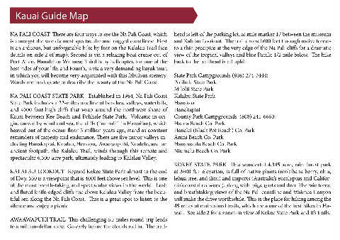
Kauai Guide Map


     NA PALI COAST  There are four ways to see the Na Pali Coast, which  head is left of the parking lot, at mile marker 17 between the museum
     is amongst the world’s most spectacular and rugged coastlines:  First  and Kalalau Lookout.  The trail drops 1600 feet through native forests
     is an arduous, but unforgetable hike by foot on the Kalalau Trail (see  to a thin precipice at the very edge of the Na Pali cliffs for a dramatic
     details on side 2 of map); Second is via a relaxing boat cruise out of  view of the tropical valleys and blue Pacific 1/2 mile below.  The hike
     Port Allen, Hanalei or Waimea; Third is by helicopter, for one of the  back to the trailhead is all uphill.
     best rides of your life; and Fourth, is via a very demanding kayak tour,
     in which you will become very acquainted with this fabulous scenery.  State Park Campgrounds (808) 274-3444:
     Words are inadequate to describe the beauty of the Na Pali Coast.  Polihale State Park
                                                              Milolii State Park
     NA PALI COAST STATE PARK   Established in 1984, Na Pali Coast  Kalalau State Park
     State Park includes a 22-mile coastline of beaches, valleys, waterfalls,  Hanakoa
     and 4000 foot-high cliffs that wrap around the northwest shore of  Hanakapiai
     Kauai between Kee Beach and Polihale State Park.  Volcanic in ori-  County Park Campgrounds  (808) 241-6660:
     gin, carved by wind and sea, the cliffs (“na pali”  in Hawaiian), which  Haena Beach Co. Park
     heaved out of the ocean floor 5 million years ago, stand as constant  Hanalei (Black Pot Beach) Co. Park
     reminders of majesty and endurance. There are five major valleys in-  Anini Beach Co. Park
     cluding Hanakapiai, Kalalau, Honopu,  Awaawapuhi, Nualolo, and  an  Hanamaulu Beach Co. Park
     ancient footpath, the Kalalau Trail, winds through this remote and  Niumalu Beach Co. Park
     spectacular 6,500-acre park, ultimately leading to Kalalau Valley.
                                                              KOKEE STATE PARK  This wonderful 4,345 acre, rain forest park
     KALALAU LOOKOUT  Beyond Kokee State Park almost to the end  at 3600 ft.+ elevation, is full of native plants (mokihana berry, ohia,
     of Hwy. 550 is a viewpoint that is 4000 feet above sea level.  This is one  lehua tree, and iliau) and imports (Australia’s eucalyptus and Califor-
     of the most breath-taking and spectacular views in the world.  Lush  nia’s coastal redwood), along with  pigs, goats and deer. The rain forest
     and fluted knife-edged cliffs rise above Kalalau Valley from the beau-  and breathtaking views of the Na Pali coastline and Waimea Canyon
     tiful sea along the Na Pali Coast.  This is a great spot to listen to the  will make the drive worthwhile.  This is the place for hiking among the
     silence and enjoy a picnic.                              45 miles of maintained trails, which are some of the best hikes in Ha-
                                                              waii.  See side 2 for a zoom-in view of Kokee State Park and it’s trails.
     AWAAWAPUHI TRAIL  This challenging 6.5 miles round-trip leads
     to a million-dollar view.  Go early before the clouds roll in.  The trail-