
Page 6 - e2_dev_designbrief
P. 6
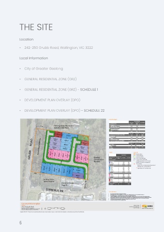
THE SITE


               Location


               •  242-250 Grubb Road, Wallington, VIC 3222


               Local Information


               •  City of Greater Geelong


               •  GENERAL RESIDENTIAL ZONE (GRZ)


               •  GENERAL RESIDENTIAL ZONE (GRZ) - SCHEDULE 1


               •  DEVELOPMENT PLAN OVERLAY (DPO)


               •  DEVELOPMENT PLAN OVERLAY (DPO) - SCHEDULE 22


                                                                                Land Budget
                                        Farming Zone / Residential
                              31m
                                        (Sensitive Interface)
                                           23.08
                                         17.21  395m²  17.24  17.24  40
                                                 712m²
                                      4.24 9.40  9.25 434m² 22.81  12.50  400m²  12.5  7.2  16  10.04  46* 22.11 43 42  41
                                                              44
                                                 32
                       GRUBB      ROAD  13  25  12.5  15.45 432m²  350m²  400m² 13.5  12.5  12.5  16  12.5  4.24 9.5  14  9.3 478m² 23.67 12.48  12.59  14.09  12.59  Yield  Legend
                                        433m²
                                        34.86
                                     12.5
                                                             14
                                                             320m²
                                               400m²
                                        34.66
                                                           455m²
                                                32
                                       34.45
                                                            37.48
                                      422m²
                                         350m²
                                                            38.98
                                       28
                                               350m²
                                                                                                    Site boundary
                                                                                                    Title boundaries
                                                 28
                                     12
                                   4.28
                                                                                                    Future road widening
                                        12.5
                                                                     Conservation
                                           12.5
                                                                                                    Contours (0.2m intervals)
                                                                     Reserve
                                                                                                    Existing vegetation to be retained
                                              15.99  12.5  10.5 4.24 373m²  25  4.24 25  11 388m²  28  12.5 350m²  28  15.85 397m²  28.2  Existing  Landscape buffer
                                                                                                    (Subject to further investigation)
                                 17.33                                                            41  Tree number
                                     16
                                         14  14  16                                                 - please refer to 'Arboricultural Assessment'
                                                                                                     February 2021, Jazzeox Pty Ltd
                                 547m²  32  512m²  448m²  32  448m²  18.01  16  533m²  4.49          * approximate tree location only
                                                         29.61
                          30m   16.81           512m²  32  576m²  34.53  13.11  12
                                                      16  568m²
                                                         36.46  16.12
                                 Existing Open
                                 Space Reserve
                                              (Oakdene Estate
                                              Stage 9)         NATAL PL
                                  CERBERUS DR
                                                                                Disclaimers
                                                                                ·  All cadastral information is derived from Vicmap;
                                                                                ·  All planning scheme Overlay definitions are CAD on-line downloads from the State Government database;
                                                                                ·  Aerial photographs are used under license from Metromap, dated 04/12/2020;
                                                                                ·  Further investigations may be needed including, but not limited to: Feature Survey, Flora and Fauna, Arboricultural Survey,
                                                                                           Archaeological, Engineering Services, Hydrological Engineering, Traffic Engineering and may not have been captured in this plan;
                                                                                ·  Staging of works and access to infrastructure may also influence the design and may not have been captured in this plan;
                                                                                ·  Concept Masterplan (draft) subject to change pending discussion with Council;
                                                                                ·  Turning areas subject to further detailed design;
                 Concept Masterplan
                                                                                                  Urban Design
                 242-250 Grubb Road                                                            Landscape Architecture
                 Date Issued: 22/06/2021 | Revision: B3                                           Town Planning
                 SMEC Project Reference: 30043051E.00  | Drawing: 01.01  0  20  40  60  80  100m
                 Drawn by: L. Nickels | Checked by: H. Norlen-Holmes  1:500 @A1  1:1000 @A3
                Copyright SMEC© 2021. This plan is based on preliminary information only and may be subject to change as a result of detailed site investigations, confirmation by survey and formal Council/Authority.
               6