
Page 195 - NGTU_paper_withoutVideo
P. 195
Modern Geomatics Technologies and Applications
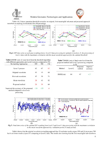
Table 4 & 5 shows operation threshold re-tracker on original, first meaningful sub,mean and proposed approach
waveform re-tracking for threshold 10 to 90 percentage.
(b) (a)
Fig.4. SST time series at each pass resulting from a: Level-2 data processing for optimal re-trackers, b: the processing of
level-1 data with the maximum correlation with the mean waveform approach for the optimal threshold
Table 6 RMSE (cm) of water level from the threshold algorithm Table 7 RMSE (cm) of final water level from the
with different approaches and Level 2 process compared to TG proposed method and Level 2 processing compared
Re-tracking Approaches 595 709 154 to TG
Proposed Improve
Level 2 process 62 67 62 Method Level-2 method accuracy
Original-waveform 43 43 68
RMSE(cm) 64 47 +17
First-sub waveform 47 39 71
Mean-waveform 28 43 82
Proposed method 28 38 66
Improved the accuracy of the proposed +34 +29 -4
method compared to level two
processing
(b) (a)
Fig.5. Final time series of the optimal SST resulting from Level-2 and Level-1 data processing with the maximum correlation
to the mean waveform approach (a: validation period, b:study period)
Table 6 shows that the original waveform re-tracking approach has 19 cm better results at pass 595 and 24 cm at pass 709
but 6 cm lower results at pass154 comparing to Level-2 data. The results also showing that the first meaningful sub-waveform
8