
Page 399 - NGTU_paper_withoutVideo
P. 399
Modern Geomatics Technologies and Applications
Consortium (OGC) in order to retrieve the desired areas from the open link data and to identify and display the critical urban
traffic hotspots.
1.1. Linked data
Nowadays, data processing and analysis, especially in spatial data, is more limited to a separate and independent data set
that requires communication between entities to achieve complex problems and perform various processes. With this in mind,
we use open-link data to investigate urban traffic nodes during rainfall in the city. This can assist to improve the experience of
storing and processing data in a way that was not previously possible, so that we can use those results to take a step towards
reducing urban traffic density through an informed urban management planning.
Over the past decade, a large number of data providers have begun to adopt linking principles. Linked data uses a Unified
Resource Locator (URL), RDF, and Hypertext Transfer Protocol (HTTP) to publish the structured data and link the related data,
which are distributed among multiple data sources. RDF is a data model for the linked data. All data items in RDF are displayed
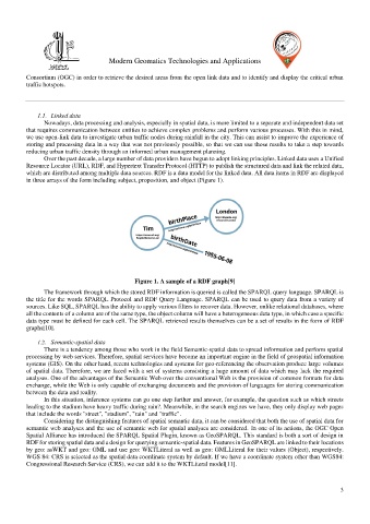
in three arrays of the form including subject, proposition, and object (Figure 1).
Figure 1. A sample of a RDF graph[9]
The framework through which the stored RDF information is queried is called the SPARQL query language. SPARQL is
the title for the words SPARQL Protocol and RDF Query Language. SPARQL can be used to query data from a variety of
sources. Like SQL, SPARQL has the ability to apply various filters to recover data. However, unlike relational databases, where
all the contents of a column are of the same type, the object column will have a heterogeneous data type, in which case a specific
data type must be defined for each cell. The SPARQL retrieved results themselves can be a set of results in the form of RDF
graphs[10].
1.2. Semantic-spatial data
There is a tendency among those who work in the field Semantic-spatial data to spread information and perform spatial
processing by web services. Therefore, spatial services have become an important engine in the field of geospatial information
systems (GIS). On the other hand, recent technologies and systems for geo-referencing the observation produce large volumes
of spatial data. Therefore, we are faced with a set of systems consisting a huge amount of data which may lack the required
analyses. One of the advantages of the Semantic Web over the conventional Web is the provision of common formats for data
exchange, while the Web is only capable of exchanging documents and the provision of languages for storing communication
between the data and reality.
In this situation, inference systems can go one step further and answer, for example, the question such as which streets
leading to the stadium have heavy traffic during rain?. Meanwhile, in the search engines we have, they only display web pages
that include the words "street", "stadium", "rain" and "traffic".
Considering the distinguishing features of spatial semantic data, it can be considered that both the use of spatial data for
semantic web analyses and the use of semantic web for spatial analyses are considered. In one of its actions, the OGC Open
Spatial Alliance has introduced the SPARQL Spatial Plugin, known as GeoSPARQL. This standard is both a sort of design in
RDF for storing spatial data and a design for querying semantic-spatial data. Features in GeoSPARQL are linked to their locations
by geo: asWKT and geo: GML and use geo: WKTLiteral as well as geo: GMLLiteral for their values (Object), respectively.
WGS 84: CRS is selected as the spatial data coordinate system by default. If we have a coordinate system other than WGS84:
Congressional Research Service (CRS), we can add it to the WKTLiteral model[11].
3