
Page 404 - NGTU_paper_withoutVideo
P. 404
Modern Geomatics Technologies and Applications
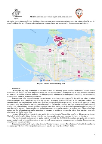
alternative routes during rainfall and decisions to improve urban management, can assist to reduce the volume of traffic and the
risk of accidents due to traffic congestion and prevent wastage of time and investment by the government and citizens.
Figure 8. Traffic hotspots during rain
3. Conclusion
In this paper, by using technologies of the semantic web and retrieving spatial-semantic information, we were able to
undertake some analyzes that were not possible before the linking data sources. Although the use of graph-based databases has
not been well received as relational databases, the ability to provide solutions to the challenges of interactivity and the scattering
of information resources promises a great success.
In many cases, it did not rain during the case study so we record large amounts of rainfall data with zero values or points
whose coordinates we are unable to record. In this approach, by storing the triple RDF data in the graph-base database, the
valueless data is not stored and thus, unlike other views, the storage of worthless data and data redundancy is prevented. It also
minimizes model inconsistencies and complexity in modeling. By injecting ontology into data such as spatial and temporal
ontology, the values obtained from retrieval have meaning. In previous studies, due to the lack of meaning in spatial and temporal
data, the results were only for one application, but in this approach, data can be reused for several purposes. The results of this
method are also information that can be understood by machines in addition to humans, but before these machines were only
able to read and display spatial data.
we were able to achieve the goal of using spatial data on the Semantic Web and the benefits for this use, as mentioned.
The lack of reliable traffic data at the time of the Corona virus spread was the most important limitation in this study.
The use of semantic web concepts in spatial context, especially the GEOSPARQL standard and spatial data storage to
achieve spatial results with significant values to move towards improving urban management and optimizing data storage, was
one of the new research activities.
Implement a spatial search engine using Semantic Web technology to improve The efficiency of using this data and using
more data sets with more relationships between members are also recommended for future studies.
8