
Page 459 - NGTU_paper_withoutVideo
P. 459
Modern Geomatics Technologies and Applications
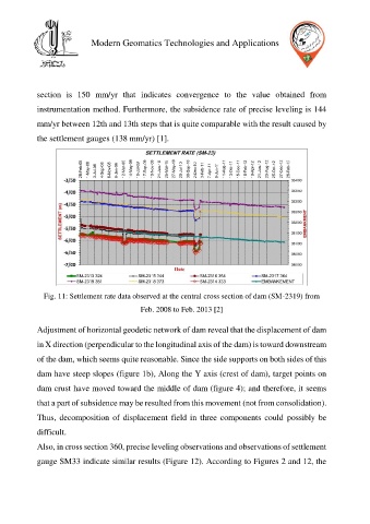
section is 150 mm/yr that indicates convergence to the value obtained from
instrumentation method. Furthermore, the subsidence rate of precise leveling is 144
mm/yr between 12th and 13th steps that is quite comparable with the result caused by
the settlement gauges (138 mm/yr) [1].
Fig. 11: Settlement rate data observed at the central cross section of dam (SM-2319) from
Feb. 2008 to Feb. 2013 [2]
Adjustment of horizontal geodetic network of dam reveal that the displacement of dam
in X direction (perpendicular to the longitudinal axis of the dam) is toward downstream
of the dam, which seems quite reasonable. Since the side supports on both sides of this
dam have steep slopes (figure 1b), Along the Y axis (crest of dam), target points on
dam crust have moved toward the middle of dam (figure 4); and therefore, it seems
that a part of subsidence may be resulted from this movement (not from consolidation).
Thus, decomposition of displacement field in three components could possibly be
difficult.
Also, in cross section 360, precise leveling observations and observations of settlement
gauge SM33 indicate similar results (Figure 12). According to Figures 2 and 12, the