Page 20 - RemoteSnsing&GIS by PK Gogoi
P. 20

16
                                                                                                          15

            basis of orbital altitude from the earth surface  revolution of satellite around the earth with its                        . Inclined Orbit Satellites (also called Sun-

            there are three types of satellites, those are viz.  ascending and descending passes, the satellite                    2Synchronous Orbit Satellite)

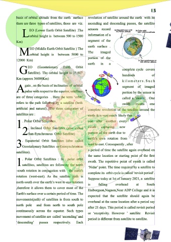
                     EO (Lower Earth Orbit Satellite) .The    sensors   record                                                             any of these satellite orbits are also sun-
                Lorbital height is between 500 to 1500        information of a                                                     Msynchronous which means in this orbit,

            Km)                                               segment of the                                                       the satellite is placed in a way so that the angle
                                                              earth surface .
                      EO (Middle Earth Orbit Satellite ) The                                                                       between the orbital plane and the line joining
                                                              The      imaged
              Morbital height is         between 5000 to                                                                           Earth and the sun remains constant. Many
                                                              portion of the
            12000 Km)                                                                                                              remote sensing platforms are designed to follow
                                                              earth    in    a                                                     an    orbit (basically north-south) which, in
                    EO     (Geostationary    Earth    Orbit
                                                                                      complete cycle covers                        conjunction with the    Earth's rotation (west-
              GSatellite). The orbital height is 35,867
                                                                                      hundreds             of                      east), allows them to cover most of the Earth's
            Km (approx 36000Km)
                                                                                      k i l o m e t e r s . S u c h                surface over a certain period of time. These are
                  gain , on the basis of inclination of orbital                       segment    of   imaged                                 near polar orbits, so named for the
            Apalne with respect to the equator, satellites                            portion by the sensor is                                        inclination  of   the  orbit

            are of three categories . Here the term ‘orbit’                           called a ‘swath’ . One                                              relative to a line running
            refers to the path followed by a satellite (both                          swath    means     one                                                between the North and

            artificial and natural). The three categories of  complete revolution of the satellite around the                                                 South poles. Many
            satellites are :                                  earth. It is very much likely that                                                              of    these satellite

            1    . Polar Orbit Satellites                     one after another every                                                                        synchronous     such
                                                                                                                                                              orbits are also sun-
                                                              swath
                                                                                    new
                                                                       capturing
                     . Inclined Orbit Satellites (also called
                 2Sun-Synchronous Orbit Satellite)            portion of the earth due to                                                                   that they cover each
                                                              earth’s own rotation from
                . Equatorial Orbit Satellites (also called                                                                                                area of the world at a
                                                              west to east. Consequently , after
            3Geostationary Satellites or Geosynchronous                                                                                              constant local time of   day
                                                              a period of time the satellite again overhead on
            satellites).                                                                                                                  called local sun time. At any given
                                                              the same location or starting point of the first                     latitude, the position of the sun in the sky as the
                . Polar Orbit Satellites : In   polar orbit
                                                              swath. The repetitive point of swath is called                       satellite passes overhead will be the same within
            1satellites, satellites are following the north
                                                              ‘Nidar’ point. The time required by a satellite to                   the same season. SPOT 4 is on a circular sun-
            -south rotation in conjugation with  the earth's
                                                              complete its orbit cycle is called ‘revisit period’.                 synchronous orbit at an altitude of 830 km with
            rotation (west-east). As the satellite path is
                                                              Suppose today at 1st of January 2021, a satellite                    an inclination of 98.8° with respect to the
            north-south over the earth’s west to east rotation
                                                              is     falling     overhead       at     South                       equator
            ,therefore it allows them to cover most of the
                                                              Haiborgaon,Nagaon,Near ADP College and it is
            Earth's surface over a certain period of time. The
                                                              expected that the satellite should again be
            movements(path) of satellites is from south to
                                                              overhead at the same location after a period say
            north pole    and from north to south pole
                                                              after 21 days. This period is called revisit period
            continuously across the equator. Such types
                                                              or ‘receptivity. However ’ satellite    Revisit
            movement of satellite are called ‘ascending’and
                                                              period is different from satellite to satellite.
            ‘descending’    passes    respectively.   Each
   15   16   17   18   19   20   21