
Page 26 - EM SOCIAL NOTES 10TH CLASS PSR DIGITAL BOOKS
P. 26
16. Name the highest peak in Southern India? (AS1)
1. Anaimudi is the highest peak in Southern India.
2. It is located in Annamalai hills with the height of 2695 mts.
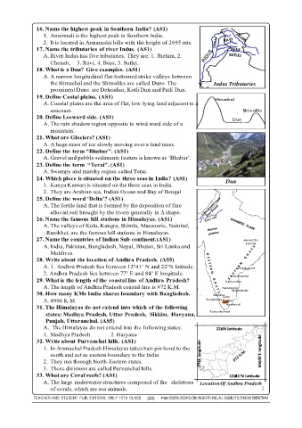
17. Name the tributaries of river Indus. (AS1)
A. River Indus has five tributaries. They are: 1. Jhelum, 2.
Chenab, 3. Ravi, 4. Beas, 5. Sutlej.
18. What is a Dun? Give examples. (AS1)
A. A narrow longitudinal flat-bottomed strike valleys between
the Himachal and the Shiwaliks are called Duns. The Indus Tributaries
prominent Duns are Dehradun, Kotli Dun and Patli Dun.
19. Define Costal plains. (AS1) Himachal
A. Coastal plains are the area of flat, low-lying land adjacent to a
seacoast. Shiwaliks
20. Define Leeward side. (AS1) Dun
A. The rain shadow region opposite to wind ward side of a
mountain.
21. What are Glaciers? (AS1)
A. A huge mass of ice slowly moving over a land mass.
22. Define the term “Bhabar”. (AS1)
A. Gravel and pebble sediments feature is known as ‘Bhabar’.
23. Define the term “Terai”. (AS1)
A. Swampy and marshy region called Terai.
24. Which place is situated on the three seas in India? (AS1)
1. Kanya Kumari is situated on the three seas in India. Dun
2. They are Arabian sea, Indian Ocean and Bay of Bengal
25. Define the word ‘Delta’? (AS1)
A. The fertile land that is formed by the deposition of fine
alluvial soil brought by the rivers generally in Δ shape.
26. Name the famous hill stations in Himalayas. (AS1)
A. The valleys of Kulu, Kangra, Shimla, Mussoorie, Nainital,
Ranikhet, are the famous hill stations in Himalayas.
27. Name the countries of Indian Sub continent.(AS1) MAHADEV
A. India, Pakistan, Bangladesh, Nepal, Bhutan, Sri Lanka and RANGE
Maldives.
28. Write about the location of Andhra Pradesh. (AS5)
A. 1. Andhra Pradesh lies between 12°41‘ N and 22°N latitude. Chinthapalli
2. Andhra Pradesh lies between 77° E and 84° E longitude.
Palakondas
29. What is the length of the coastal line of Andhra Pradesh? Velikondas
A. The length of Andhra Pradesh coastal line is 972 K.M. Nallamalas
30. How many KMs India shares boundary with Bangladesh. Gudalur Ooty Seshachala
A. 4906 K.M. Dodda Betta Palani
31. The Himalayas do not extend into which of the following Anaimudi
states: Madhya Pradesh, Uttar Pradesh, Sikkim, Haryana, Kanyakumari
Punjab, Uttaranchal. (AS5)
A. The Himalayas do not extend into the following states: 22¢N latitude
1. Madhya Pradesh 2. Haryana
32. Write about Purvanchal hills. (AS1)
1. In Arunachal Pradesh Himalayas takes hair pin bend to the
south and act as eastern boundary to the India. 77¢E longitude 84¢40‘E longitude
2. They run through North-Eastern states.
3. These divisions are called Purvanchal hills.
33. What are Coral reefs? (AS1) 12¢41‘N latitude
A. The large underwater structures composed of the skeletons Location Of Andhra Pradesh
of corals, which are sea animals. 2
TEACHER AND STUDENT PUBLICATIONS, ONLY 10TH CLASS (20) PSR DIGITAL BOOKS (ONLINE&OFFLINE), ALL SUBJECTS (TM&EM) 9885678410