
Page 28 - EM SOCIAL NOTES 10TH CLASS PSR DIGITAL BOOKS
P. 28
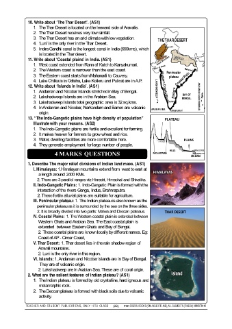
10. Write about ‘The Thar Desert’. (AS1)
                  1. The Thar Desert is located on the leeward side of Aravalis.
                  2. The Thar Desert receives very low rainfall.
                  3. The Thar Desert has an arid climate with low vegetation.
                                                                                  THE THAR DESERT
                  4. ‘Luni’ is the only river in the Thar Desert.
                  5. Indira Gandhi canal is the longest canal in India (650kms), which
                     is located in the Thar desert.
               11. Write about ‘Coastal plains’ in India. (AS1)India (650kms), which
                     Indira Gandhi canal is the longest canal in
                  1. West coast extended from Rann of Kutch to Kanyakumari.
                  2. The Western coast is narrower than the east coast.
                                                                                      Peninsular
                  3. The Eastern coast starts from Mahanadi to Cauvery.                 plateau
                  4. Lake Chilka is in Odisha, Lake Kolleru and Pulicat are in A.P.
               12. Write about ‘Islands in India’. (AS1)                         LAKSHADWEEP
                  1. Andaman and Nicobar Islands stretched in Bay of Bengal.
                                                                                               BAY OF
                  2. Lakshadweep Islands are in the Arabian Sea.                                       ANDAMAN AND NICOBAR
                                                                                              BENGAL.
                  3. Lakshadweep Islands total geographic  area is 32 sq.kms.          Cauvery
                  4. In Andaman and Nicobar, Narkondam and Barren are volcanic
                                                                               ARABIAN SEA.  Kanyakumari
                     origin.
               13. “The Indo-Gangetic plains have high density of population”         PLATEAU
                  Illustrate with your reasons. (AS2)
                  1. The Indo-Gangetic plains are fertile and excellent for farming.
                  2. It makes heaven for farmers to grow wheat and rice.
                  3. Water, dwelling facilities are more comfortable here.                     PLAINS
                  4. They generate employment for large number of people.
                                                                                                     SEA LEVEL
                             4 MARKS QUESTIONS                                  MOUNTAINS   HILLS  OCEAN

               1. Describe The major relief divisions of Indian land mass. (AS1)
                  I. Himalayas: 1.Himalayan mountains extend from  west to east at   HIMALAYAS
                     a length around  2400 KMs.
                    2. There are 3 parallel ranges viz Himadri, Himachal and Shivaliks.
                  II. Indo-Gangetic Plains: 1. Indo-Gangetic Plain is formed with the
                    interaction of the rivers Ganga, Indus, Brahmaputra.
                    2. These fertile alluvial plains are suitable for agriculture.
                  III. Peninsular plateau: 1. The Indian plateau is also known as the
                    peninsular plateau as it is surrounded by the sea on the three sides.
                    2. It is broadly divided into two parts: Malwa and Deccan plateaus.  THAR DESERT
                  IV. Coastal Plains: 1. The Western coastal plain is extended between
                                                Gangetic Plain is formed with the
                     Western Ghats and Arabian Sea. The East coastal plain is
                     extended  between Eastern Ghats and Bay of Bengal.
                     2. These coastal plains are known locally by different names. Eg:
                     Coast of AP - Circar Coast,
                  V. Thar Desert: 1. Thar desert lies in the rain shadow region of
                     Aravali mountains.
                     2. Luni is the only river in this region.
                                   1. The Western coastal plain is extended between
                  VI. Islands: 1. Andaman and Nicobar islands are in Bay of Bengal.
                     They are of volcanic origin.
                     2. Lakshadweep are in Arabian Sea. These are of coral origin.
               2. What are the salient features  of Indian plateau? (AS1)                Island
                  1. The Indian plateau is formed by old crystalline, hard igneous and
                     metamorphic rock.
                  2. The Deccan plateau is formed with black soils due to volcanic
                     activity.


              TEACHER AND  STUDENT  PUBLICATIONS,  ONLY  10TH  CLASS  (22)  PSR  DIGITAL BOOKS (ONLINE&OFFLINE), ALL SUBJECTS (TM&EM) 9885678410