
Page 82 - Our Favourite Walks by Brian Everingham
P. 82
DAIRY FARMS TO MAJOR TOURIST ATTRACTION THE KIAMA COAST WALKING TRACK
Kevin Mills
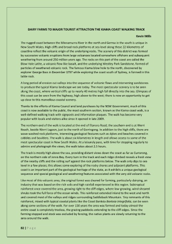
The rugged coast between the Minnamurra River in the north and Gerroa in the south is unique in
New South Wales. High cliffs and broad rock platforms at sea level along these 22 kilometres of
coastline reflect the volcanic origin of the underlying rocks. The scenery of this district was formed
by successive volcanic eruptions from large volcanoes located somewhere offshore and subsequent
weathering from around 250 million years ago. The rocks on this part of the coast are called the
Blow Hole Latite, a volcanic flow like basalt, and the underlying Westley Park Sandstone, formed of
particles of weathered volcanic rock. The famous Kiama blow hole to the north, discovered by
explorer George Bass in December 1797 while exploring the coast south of Sydney, is formed in this
latite rock.
A long period of erosion cut valleys into the sequence of volcanic flows and intervening sandstones
to produce the typical Kiama landscape we see today. The most spectacular scenery is to be seen
along the coast, where vertical cliffs up to nearly 40 metres high fall directly into the sea. Glimpses of
this coast can be seen from the highway, high above to the west; there is now an opportunity to get
up close to this marvellous coastal scenery.
Thanks to the efforts of Kiama Council and land purchases by the NSW Government, much of this
coast is now available to the public, the most southern section, known as the Kiama coast walk, is a
well-defined walking track with signposts and information plaques. The walk has become very
popular with locals and visitors alike since it opened in late 2009.
The northern end of the walk is located at the end of Elanora Road; the southern end is at Werri
Beach, beside Werri Lagoon, just to the north of Gerringong. In addition to the high cliffs, there are
wave-washed rock platforms, interesting geological features such as dykes and beaches covered in
cobbles and boulders. The walk is about six kilometres in length and allows access to some of the
most spectacular coast in New South Wales. At a leisurely pace, with time for stopping regularly to
admire and photograph the views, the walk takes about 2.5 hours.
The track is mostly high above the sea, providing distant views down the coast as far as Currarong,
on the northern side of Jervis Bay. Every turn in the track and each ridge climbed reveals a fresh view
of the nearby cliffs and the rolling surf against the rock platforms below. The walk only dips to sea
level in a few places; this allows some exploring of the rocky shores and adjacent platforms. This
coast is an important part of the geological heritage of the state, as it exhibits a unique geological
sequence and special geological and weathering features associated with the very old volcanic rocks.
Like most of this volcanic area, the original forest was cleared for farming, particularly dairying, an
industry that was based on the rich soils and high rainfall experienced in this region. Subtropical
rainforest once covered the area, growing right to the cliff edges, where low-growing, wind-sheared
shrubs took the full force of the ocean winds. This rainforest extended inland to the west and north
and covered most of the valleys and ridges surrounding Saddleback Mountain. Tiny remnants of this
rainforest, mixed with typical coastal plants like the Coast Banksia Banksia integrifolia, can be seen
along some sections of the walk. For over 150 years the area was farmed and today almost the
entire coast is completely treeless, the grazing paddocks extending to the cliff edges. Since the
farming stopped and stock was excluded by fencing, the native plants are slowly returning to the
area around the walk.
82 | P a g e