
Page 27 - Newham SuDS DESIGN & EVALUATION GUIDE
P. 27
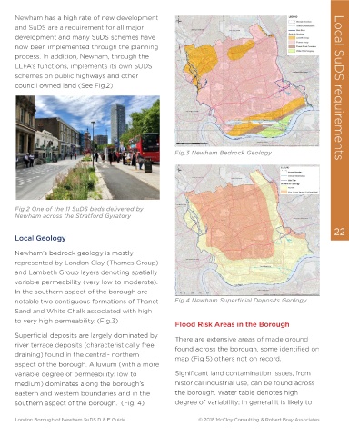
6.0  Local SuDS requirements for  Newham has a high rate of new development
 Local SuDS requirements
      and SuDS are a requirement for all major
 The London Borough of Newham
      development and many SuDS schemes have
      now been implemented through the planning
      process. In addition, Newham, through the

 Landscape Character  There are some notable areas of open space   LLFA’s functions, implements its own SUDS
 including West Ham Park, Beckton District   schemes on public highways and other
 The London Borough of Newham (LBN),   Park and Thames Barrier Park, but the   council owned land (See Fig.2)      Local SuDS requirements
 located on the north side of the River   majority of the Borough is densely developed
 Thames, encompasses an area of 3,600   with predominantly impermeable surface
 hectares bound on three sides by tidal   creating conditions for flash flooding and
 watercourses. The River Lee and the River   water ponding in low lying area.
 Roding, both flowing south, form the western   Legend  THIS DRAWING MAY BE USED ONLY FOR
   THE PURPOSE INTENDED
 and the eastern boundary with the River   NORTH  Borough Administrative Boundary
 Sewage Treatment Works Locations
 Pumping Stations
 WALTHAM FOREST  REDBRIDGE  Combined Sewer Overflow Locations
 Thames to the south.   Other                                Fig.3 Newham Bedrock Geology
 Pumping Stations
 Combined Sewer
 The Royal Docks located in the south of the   Surface Water Sewer
 Other Sewers
 Borough on historical River Thames riverside
 marshes collectively form the largest   Notes
 1. Foul drainage network not displayed;
 BARKING AND DAGENHAM  2. Drainage networks with a diameter less than 150mm not
     displayed.
 enclosed docks in the world and a major       Thames Water. Any queries relating to connectivity should go
 3. The pipe network shown on this drawing is as supplied by
     directly to Thames Water.
  London Borough of
 feature of the Borough.  The Thames Barrier   Newham
      Fig.2 One of the 11 SuDS beds delivered by
 mediates tidal influence on the River Thames   © Crown Copyright. All rights reserved. GLA (LA100032379) 2011
 Surface Water Management Plan
      Newham across the Stratford Gyratory
 and the Lea; the Barking Creek Barrier   Covers all data that has been supplied and distributed under
 license for the Drain London project.
 Digital geological data reproduced from British Geological Survey
 (c) NERC Licence No 2011/053A
 21   protects the River Roding.  Locks regulates   TOWER HAMLETS  Scale at A3 Thames Water Sewer Network Approved by  22
  Date
      Drawn by
      S.TURNBULL
 1:30,000
  07/04/2011
          S.IP
 water level within the Royal docks.  Filepath: L:\Environment\zwet\CS046913_DrainLondon_Tier2\Group4\ARC\mxds\GP4_Newham_Fig9_TWSewerNetwork.mxd  Consultants  Local Geology
         Capita Symonds
         Level Seven,
         52 Grosvenor Gardens,
         Belgravia,
         London
         SW1W 0AU
      Newham’s bedrock geology is mostly
 The borough’s terrain generally slopes in a   Drain London Programme Board Members
      represented by London Clay (Thames Group)
 southerly direction towards the River Thames   GREENWICH 0.25  0.5  1  1.5  2 Kilometres  FIGURE 8
 0
 and the Royal Docks.  The borough is   Fig.1 Newham Sewer Infrastructure: combined   and Lambeth Group layers denoting spatially
 (Brown); Stormwater (Blue)
 dissected by artificial landforms   variable permeability (very low to moderate).
 corresponding to railways and other   Newham has been assessed as having the   In the southern aspect of the borough are
 infrastructures (e.g. the Greenway - Norther   lowest sewer capacity of all 33 London   notable two contiguous formations of Thanet   Fig.4 Newham Superficial Deposits Geology
 Outfall Sewer). These features can act as   Borough (Thames Water’s assessment).   Sand and White Chalk associated with high
 barriers to or conveyors of overland runoff   Newham’s overall sewer infrastructure, as a   to very high permeability. (Fig.3)  Flood Risk Areas in the Borough
 and determine conditions for localised   whole is nearing capacity and projected to   Superficial deposits are largely dominated by
 flooding during rainstorms.                                 There are extensive areas of made ground
 be over capacity within next 20-30 years.   river terrace deposits (characteristically free   found across the borough, some identified on
 Newham’s urban fabric comprises traditional   More than half of Newham’s sewer   draining) found in the central- northern   map (Fig 5) others not on record.
 Victorian terraces (north and east) with an   infrastructure consists of a historical   aspect of the borough. Alluvium (with a more
 increasing mix of high density mixed-use   combined sewer system denoting very low   variable degree of permeability: low to   Significant land contamination issues, from
 development replacing disused or underused   capacity which makes the borough   medium) dominates along the borough’s   historical industrial use, can be found across
 industrial land in the south and west as well   particularly prone to surface water flooding   eastern and western boundaries and in the   the borough. Water table denotes high
 as a number of post-war housing estates.   during rainstorms.   southern aspect of the borough.  (Fig. 4)  degree of variability; in general it is likely to
 London Borough of Newham SuDS D & E Guide                                                     © 2018 McCloy Consulting & Robert Bray Associates  London Borough of Newham SuDS D & E Guide                                                     © 2018 McCloy Consulting & Robert Bray Associates