Page 74 - Newham SuDS DESIGN & EVALUATION GUIDE
P. 74

Detailed Design  9.3  Typical Detailed Design package                                                                  9.3.2  Drawing package                                                                                       Detailed Design

           The Detailed Design package should be
                                                                                                                             The SuDS drawing package should include
           proportionate to the scale of the
                                                                                                                             the following:
           development and will generally encompass a
                                                                                                                                               Topographical survey of the site
                                                                                                                              Design
           design statement with accompanying
                                                                                                                              information
           drawings. Supporting information including
                                                                                                                                               Coordinated constraints map identifying all potential design constraints including
                                                                                                                              drawings
           calculations, maintenance plan and risk
                                                                                                                                               areas of flood risk (fluvial, pluvial and ground water), contaminated land,
           assessment will also be required.
                                                                                                                                               archaeological significance, poor ground conditions, unexploded ordnance (UXO),
                                                                                                                                               presence of invasive species, protected habitats, tree Protection Orders (TPO) and
                                                                                                                                               root protection zones (RPZ). [note : list is not exhaustive]
           9.3.1  SuDS Design Statement                                                                                                        Existing utility services drawing. Details of existing site surface water drainage

                                                                                                                                               infrastructure and ownership established
           The SuDS Design Statement should cover                    ■  outline how requirements of NPPF, NSTS,
           SuDS provisions on quantity, quality, amenity             local SuDS policies, requirements for                                     Plan of site detailing flow routes including exceedance flow routes, subcatchment
           and biodiversity and how opportunities                    multi-functional use of SuDS space and                                    boundaries, flow control locations, storage locations, contributing impermeable area,
           provided by the site have been maximised                  local objectives for sustainability including                             and phasing where appropriate;
           along with addressing the following:                      climate resilience are dealt with                                         Drawing of site drainage catchment areas showing permeable and impermeable areas
                                                                                                                                               within defined subcatcatchments.
              ■  confirm drainage design criteria agreed             ■  explain how SuDS will function passively
               with LPA. For example, rainfall return                in terms of treatment and management
               periods, discharge allowance, traffic                                                                          Design           Detailed site layout at an identified scale (1:200 or 1:500 or as appropriate or any other
               loading requirements etc                              ■  outline details of any offsite works                  drawings         scale agreed) including a North direction arrow.
  69          ■  summarise the findings of the FRA and               required, together with any necessary                                     Long sections and cross sections for the proposed drainage system, including               70
                                                                     consents.
               highlight any other significant site                                                                                            surrounding site level and proposed finished floor levels (where appropriate)

               constraints                                                                                                                     Construction Details – inlets, outlets, flow controls, storage, edge details, connection
                                                                                                                                               details to receiving watercourse / sewers / public surface water sewers / highway
                                                                                                                                               drains;

                                                                                                                                               Planting arrangement and surface treatment / materials drawings where detailed not
                                                                                                                                               included on other drawings.

                                                                                                                                               Critical design levels should be identified on all relevant drawings.
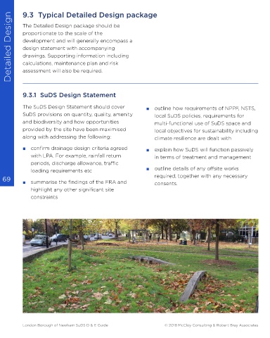


                                                                                                                             Facing:
                                                                                                                             Rectory Gardens Rainpark, Hornsey.
                                                                                                                             A small public park that collects polluted road
                                                                                                                             runoff through silt forebays and underdrained
                                                                                                                             infiltration basins that discharge clean water
                                                                                                                             slowly to the River Moselle.


           London Borough of Newham SuDS D & E Guide                                                     © 2018 McCloy Consulting & Robert Bray Associates  London Borough of Newham SuDS D & E Guide                                                     © 2018 McCloy Consulting & Robert Bray Associates
   69   70   71   72   73   74   75   76   77   78   79