
Page 5 - TalesoftheParadiseRidge-Fall2020_Neat
P. 5
power company for agricultural use in Butte Valley and
Coal Canyon. In the early 1900s, Pacific Gas and Electric
acquired the system and has owned and operated it ever
since (Miocene Canal Coalition).
Although the Miocene traverses approximately 25 miles,
extending from the head dam below Magalia all the way
to Thompson’s Flat in Thermolito, the section from the
head dam to Kunkle Reservoir is what most Ridge resi-
dents would consider “the Flume,” or, more recently, “the
Flumes.” This stretch of the canal has been widely used by
generations of hikers and swimmers as the pathway along
the West Branch providing access to numerous swim-
ming and fishing holes, as well as outstanding vistas of
the canyon for hikers. This section of the canal consists of
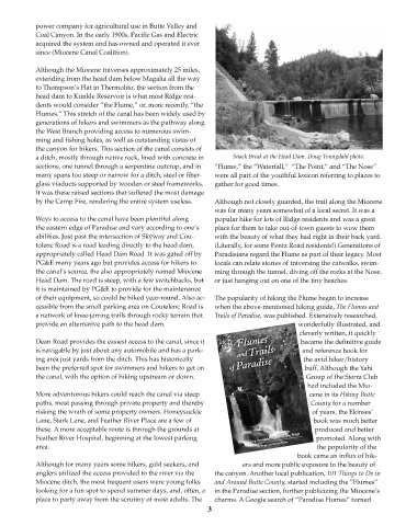
a ditch, mostly through native rock, lined with concrete in Snack Break at the Head Dam. Doug Youngdahl photo.
sections, one tunnel through a serpentine outcrop, and in “Flume,” the “Waterfall,” “The Point,” and “The Nose”
many spans too steep or narrow for a ditch, steel or fiber- were all part of the youthful lexicon referring to places to
glass viaducts supported by wooden or steel frameworks. gather for good times.
It was these raised sections that suffered the most damage
by the Camp Fire, rendering the entire system useless. Although not closely guarded, the trail along the Miocene
was for many years somewhat of a local secret. It was a
Ways to access to the canal have been plentiful along popular hike for lots of Ridge residents and was a great
the eastern edge of Paradise and vary according to one’s place for them to take out-of-town guests to wow them
abilities. Just past the intersection of Skyway and Cou- with the beauty of what they had right in their back yard.
tolenc Road is a road leading directly to the head dam, (Literally, for some Pentz Road residents!) Generations of
appropriately called Head Dam Road. It was gated off by Paradisians regard the Flume as part of their legacy. Most
PG&E many years ago but provides access for hikers to locals can relate stories of traversing the catwalks, swim-
the canal’s source, the also appropriately named Miocene ming through the tunnel, diving off the rocks at the Nose,
Head Dam. The road is steep, with a few switchbacks, but or just hanging out on one of the tiny beaches.
it is maintained by PG&E to provide for the maintenance
of their equipment, so could be hiked year-round. Also ac- The popularity of hiking the Flume began to increase
cessible from the small parking area on Coutelenc Road is when the above-mentioned hiking guide, The Flumes and
a network of knee-jarring trails through rocky terrain that Trails of Paradise, was published. Extensively researched,
provide an alternative path to the head dam. wonderfully illustrated, and
cleverly written, it quickly
Dean Road provides the easiest access to the canal, since it became the definitive guide
is navigable by just about any automobile and has a park- and reference book for
ing area just yards from the ditch. This has historically the avid hiker/history
been the preferred spot for swimmers and hikers to get on buff. Although the Yahi
the canal, with the option of hiking upstream or down. Group of the Sierra Club
had included the Mio-
More adventurous hikers could reach the canal via steep cene in its Hiking Butte
paths, most passing through private property and thereby County for a number
risking the wrath of some property owners. Honeysuckle of years, the Ekinses’
Lane, Stark Lane, and Feather River Place are a few of book was much better
these. A more acceptable route is through the grounds at produced and better
Feather River Hospital, beginning at the lowest parking promoted. Along with
area. the popularity of the
book came an influx of hik-
Although for many years some hikers, gold seekers, and ers and more public exposure to the beauty of
anglers utilized the access provided to the river via the the canyon. Another local publication, 101 Things to Do in
Miocene ditch, the most frequent users were young folks and Around Butte County, started including the “Flumes”
looking for a fun spot to spend summer days, and, often, a in the Paradise section, further publicizing the Miocene’s
place to party away from the scrutiny of most adults. The charms. A Google search of “Paradise Flumes” turned
3