
Page 361 - Environment: The Science Behind the Stories
P. 361
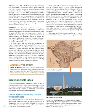
(2.5 million acres) of U.S. land converted each year, roughly   Washington, D.C., is the earliest example of city plan-
                     60% is agricultural land and 40% is forest. These lands pro-  ning in the United States. President George  Washington
                     vide vital resources, recreation, aesthetic beauty, wildlife   hired French architect Pierre Charles L’Enfant in 1791 to
                     habitat, air and water purification, and other ecosystem ser-  design a capital city for the new nation on undeveloped land
                     vices (pp. 21, 134–135, 170, 308). Sprawl generally dimin-  along the Potomac River. L’Enfant laid out a Baroque-style
                     ishes all these amenities. Perhaps of most concern, more and   plan of diagonal avenues cutting across a grid of streets, with
                     more children these days are growing up without the ability   plenty of space allotted for majestic public monuments, and
                     to roam through woods, fields, and open space, which used   the city was built according to his plan (FIGURE 13.6). A cen-
                     to be a normal part of childhood. Being deprived of access to   tury later, as the city became crowded and dirty, a special
                     regular experience with nature as a child, many experts feel,   commission in 1901 undertook new planning efforts to beau-
                     can have psychological and emotional consequences for the   tify the city while staying true to the intentions of L’Enfant’s
                     individual and for society (p. 312).                 original plan. These planners imposed a height restriction on
                                                                          new buildings, which kept the magnificent government edi-
                     Economics    Sprawl drains tax dollars from existing com-  fices and monuments from being crowded and dwarfed by
                     munities and funnels money into infrastructure for new devel-  modern skyscrapers. This preserved the spacious, stately feel
                     opment on the fringes of those communities. Funds that could   of the city.
                     be spent maintaining and improving downtown centers is   City planning in North America came into its own at the
                     instead spent on extending the road system, water and sewer   turn of the 20th century, as urban leaders sought to beautify
                     system, electricity grid, telephone lines, police and fire ser-
                     vice, schools, and libraries. The costs of extending infrastruc-
                     ture are generally paid by taxpayers of the community and are
                     not charged to developers.
                        One study calculated that sprawling development at
                     Virginia Beach, Virginia, would require 81% more in infra-
                     structure costs and would drain 3.7 times more from the
                     community’s general fund each year than compact urban
                     development.  Advocates for sprawling development argue
                     that as owners of newly developed homes and businesses pay
                     property taxes, this revenue eventually reimburses the com-
                     munity’s investment in extending infrastructure. However,
                     studies have found that in most cases taxpayers continue to
                     subsidize new development unless municipalities specifically
                     require that developers pay new infrastructure costs.


                       WEIGHING THE ISSUES
                       SPRAWL NEAR YOU  Is there sprawl in the area where you live?
                       Does it bother you, or not? Has development in your area had   (a) The L’Enfant plan, 1791
                       any of the impacts described above? Do you think your city
                       or town should encourage outward growth? Why or why not?


                     Creating Livable Cities


                     To respond to the challenges that sprawl presents, architects,
                     planners, developers, and policymakers are trying to restore
                     the vitality of city centers and to plan and manage how urban-
                     izing areas develop. They aim to make cities safer, cleaner,
                     healthier, and more pleasant for their residents.

                     City and regional planning help to create
                     livable urban areas                                  (b) Washington, D.C., today

                     How can we design cities so as to maximize their efficiency,   FIGURE 13.6 Washington, D.C., is a prime example of early
                     functionality, and beauty? These are the questions central to   city planning. The 1791 plan (a) for the new U.S. capital laid out a
                     city planning (also known as urban planning). City planners   series of splendid diagonal avenues cutting across gridded streets,
                     advise policymakers on development options, transportation   allowing plenty of space for the magnificent public monuments
             360     needs, public parks, and other matters.              (b) that still grace the city today.


           M13_WITH7428_05_SE_C13.indd   360                                                                                   19/12/14   10:35 AM