
Page 362 - Environment: The Science Behind the Stories
P. 362
and impose order on fast-growing, unruly cities. Landscape coordinate their work with multiple municipal governments.
architect Daniel Burnham’s 1909 Plan of Chicago was In some places, regional planning has been institutionalized
perhaps the grandest effort of this time, and it was largely in formal government bodies; the Portland area’s Metro is the
implemented over the following years and decades. Burn- epitome of such a regional planning entity. When Metro and
ham’s plan expanded Chicago’s city parks and playgrounds, its region’s three counties in 2010 announced their collabora-
improved neighborhood living conditions, streamlined traffic tive plan on how to apportion their remaining undeveloped
systems, and cleared industry and railroads from the shore of land into “urban reserves” and “rural reserves,” it marked a
Lake Michigan to provide public access to the lake. historic accomplishment in regional planning. The agreement,
Portland gained its own comprehensive plan just three hammered out after two years of complicated negotiations,
years later, in 1912. Edward Bennett’s Greater Portland Plan designates 28,000 acres for urban use and 272,000 acres for
recommended rebuilding the harbor; dredging the river chan- rural use. It means that homeowners, farmers, developers, and
nel; constructing new docks, bridges, tunnels, and a water- policymakers alike can feel informed and secure knowing
front railroad; superimposing wide radial boulevards on the what kinds of land uses lie in store on and near their land over
old city street grid; establishing civic centers downtown; and the next half-century.
greatly expanding the number of parks. Voters approved the
plan by a two-to-one margin, but they defeated a bond issue
that would have paid for park development. As the century Zoning is a key tool for planning
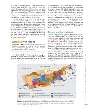
progressed, several other major planning efforts were con- One tool that planners use is zoning, the practice of classi-
ducted, and some ideas, such as establishing a downtown pub- fying areas for different types of development and land use
lic square, came to fruition. (FIGURE 13.7). For instance, to preserve the cleanliness and
tranquility of residential neighborhoods, industrial facilities
WEIGHING THE ISSUES may be kept out of districts zoned for residential use. By spec-
ifying zones for different types of development, planners can
YOUR URBAN AREA Think of your favorite parts of the city you guide what gets built where. Zoning also gives home buyers
know best. What do you like about them? What do you dislike and business owners security, because they know in advance
about your least favorite parts of the city? What could this city what types of development can and cannot be located nearby.
do to improve quality of life for its residents? Zoning involves government restriction on the use of pri-
vate land and represents a top-down constraint on personal
property rights. For this reason, some people consider zoning
In today’s world of sprawling metropolitan areas, regional a regulatory taking (p. 188) that violates individual freedoms.
planning has become at least as important as city planning. Most people defend zoning, however, saying that government
Regional planners deal with the same issues as city plan- has a proper and useful role in setting limits on property rights
ners, but they work on broader geographic scales and must for the good of the community.
EAST BRANDYWINE
WEST BRANDYWINE
DOWNINGTOWN
DOWNINGTOWN CHAPTER 13 • THE URB AN ENVIR ONMENT : CREATING SUSTAIN ABLE CITIES
VALLEY
WEST BRADFORD
COATESVILLE
EAST FALLOWFIELD
Highway commercial Low-density residential Medium- to high-density residential
Regional commercial Low- to medium-density residential Pre existing planned residential community
Industrial Medium-density residential Thorndale Village
FIGURE 13.7 This zoning map for Caln Township, Pennsylvania, shows several common zoning
patterns. Public and institutional uses are clustered together in a downtown area. Industrial uses are clustered
away from residential areas. Commercial uses are aligned along major roadways. Residential zones generally
are higher in density toward the center of town. 361
M13_WITH7428_05_SE_C13.indd 361 12/12/14 4:59 PM