
Page 16 - PowerPoint Presentation
P. 16
PROJECT ALIGNMENT
In early 2012 Nagpur Improvement Trust (NIT) requested DMRC to provide
Consultancy services for preparation of a Detailed Project Report for Metro Rail
System in Nagpur, Maharashtra initially for 30 Km which was revised to 42 Km in July
2012. Thereafter, DMRC conducted Traffic Surveys, Topographical Surveys,
Geotechnical Investigations and Environment Impact Assessment Survey. The study
area consisted of Nagpur Municipal Corporation Area. The study area totalled to
approximately 217 sq km. Based on the different types of surveys done by DMRC,
metro alignments were finalized after repeated inspection of the road network,
intersections, passenger traffic flow, traffic congestion, connectivity to important
land uses.
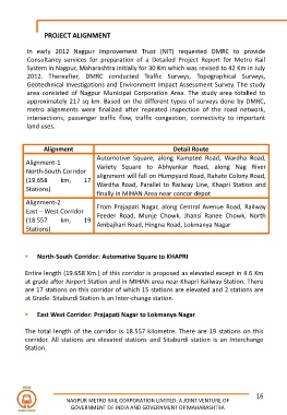
Alignment Detail Route
Automotive Square, along Kamptee Road, Wardha Road,
Alignment-1
Variety Square to Abhyankar Road, along Nag River
North-South Corridor
alignment will fall on Humpyard Road, Rahate Colony Road,
(19.658 km, 17
Wardha Road, Parallel to Railway Line, Khapri Station and
Stations)
finally in MIHAN Area near concor depot
Alignment-2
From Prajapati Nagar, along Central Avenue Road, Railway
East – West Corridor
Feeder Road, Munje Chowk, Jhansi Ranee Chowk, North
(18.557 km, 19
Ambajhari Road, Hingna Road, Lokmanya Nagar
Stations)
▪ North-South Corridor: Automative Square to KHAPRI
Entire length (19.658 Km.) of this corridor is proposed as elevated except in 4.6 Km
at grade after Airport Station and in MIHAN area near Khapri Railway Station. There
are 17 stations on this corridor of which 15 stations are elevated and 2 stations are
at Grade. Sitaburdi Station is an Inter-change station.
▪ East West Corridor: Prajapati Nagar to Lokmanya Nagar
The total length of the corridor is 18.557 kilometre. There are 19 stations on this
corridor. All stations are elevated stations and Sitaburdi station is an Interchange
Station.
16
NAGPUR METRO RAIL CORPORATION LIMITED: A JOINT VENTURE OF
GOVERNMENT OF INDIA AND GOVERNMENT OF MAHARASHTRA