
Page 21 - Bernardon Dover Master Plan Booklet
P. 21
A MORE CONNECTED COMMUNITY
SITE ANALYSIS
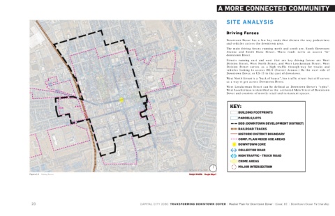
Driving Forces
Downtown Dover has a few key roads that dictate the way pedestrians
and vehicles access the downtown area.
The main driving forces running north and south are, South Governors
Avenue and South State Street. These roads serve as access "to"
downtown Dover.
Streets running east and west that are key driving forces are West
Division Street, West North Street, and West Loockerman Street. West
Division Street serves as a high traffic through-way for trucks and
vehicles looking to access DE-8 (Forrest Avenue.) On the west side of
Downtown Dover, or US-13 to the east of downtown.
West North Street is a "back of house", low traffic street but still serves
as a way to get across Downtown Dover.
West Loockerman Street can be defined as Downtown Dover's "spine".
West Loockerman is identified as the activated Main Street of Downtown
Dover and consists of mostly retail and restaurant spaces.
KEY:
BUILDING FOOTPRINTS
PARCELS/LOTS
DDD (DOWNTOWN DEVELOPMENT DISTRICT)
RAILROAD TRACKS
HISTORIC DISTRICT BOUNDARY
COMP. PLAN MIXED USE AREAS
DOWNTOWN CORE
COLLECTOR ROAD
HIGH TRAFFIC - TRUCK ROAD
CRIME AREAS
MAJOR INTERSECTION
SCALE: 1" = 200'
Image Credit:
Figure 1.3 Driving Forces Image Credit: Google Maps?
Googl
e Maps?
20 CAPITAL CITY 2030: TRANSFORMING DOWNTOWN DOVER | Master Plan for Downtown Dover | Dover, DE | Downtown Dover Partnership