Page 410 - A Hand Book of Arabia Vol 2_Neat
P. 410
( {
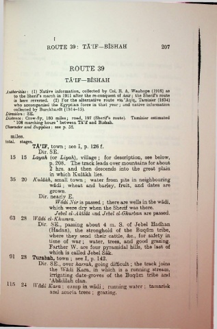
                         ROUTE 39 : TA’IF—BlSHAH                                   207


                                    ROUTE 39

                                  TA’IF—BlSHAH

    Authorities: (1) Native information, collected by Col. R. A. Wauhope (1916) as
        to the Sherif’s march in 1911 after the re-conquest of Asir; the Sherif’s route
        is here reversed. (2) For the alternative route via ‘Aqiq, Taraisier (1834)
        who accompanied the Egyptian force in that year ; and native information
        collected by Burckhardt (1814-15).
    Direction: SE.
    Distance: Crow-fly, 180 miles; road, 197 (Sherif’s route). Tamisier estimated
        ‘ 108 marching hours ’ between Ta’if and Bishah.
    Character and Supplies: see p. 52.
      miles.
    total, stages.
                 TA’IF, town ; see I, p. 126 f.
                    Dir. SE.
      15 15      Layah (or Liyah), village ; for description, see below,
                          p. 208. The track leads over mountains for about
                          2 hrs. and then descends into the great plain
                          in which Kulakh lies.
      35 20       Kulakh, small town ; water from pits in neighbouring
                          wadi ; wheat and barley, fruit, and dates are
                          grown.
                     Dir. nearly E.

                             Wadi Nir is passed ; there are wells in the wadi,
                          which were dry when the Sherif was there.
                             Jebel el-Akildt and Jebel el-Ghurban are passed.
      63 28       Wadi el-Khumra.

                    Dir. SE., passing about 4 m. S. of Jebel Hadhan
                          (Hadan), the stronghold of the Buqum tribe,
                          where they send their cattle, &c., for safety in
                          time of war ; water, trees, and good grazing.
                          Farther W. are four pyramidal hills, the last of
                          which is called Jebel Sak.
      91 28      Tuxabah, town ; see I, p. 142.

                    Dir. SE., over harrah, going difficult; the track joins
                          the Wadi Kara, in which is a running stream,
                          irrigating date-groves of the Buqum tribe and
                          ‘Abadilah clan.
     115  24      II ddi Kara \    camp in wadi ; running water ; tamarisk

                          and acacia trees ; grazing.

