
Page 92 - Art In The Age Of Exploration (Great Section on Chinese Art Ming Dynasty)
P. 92
star at the port of destination; they then set And when Vasco da Gama showed him the
course eastward. large astrolabe of wood that he had with him,
This technique was first adopted about 1460 and others of metal with which he measured
and is associated with the Portuguese navigator, the altitude of the sun, the Moor [that is, the
Diogo Gomes. The navigators used a simple mu'allim] was not impressed, saying that
altitude-measuring instrument known as a some navigators of the Red Sea used brass
quadrant, which consists of a small plate of instruments of triangular shape and quad-
wood or brass in the form of a quarter disk with rants with which they measured the altitude
a scale of degrees engraved along the curved of the sun, and especially of the star which
edge, a plumb-line and bob suspended from the they most used in navigation. But he, and the
apex, and a pair of pinhole sight vanes attached mariners of Cambay and of the whole of
24
at either end of one of the radii. By sighting India, because their navigation was by means
the polestar through the pinhole sights, holding of certain stars, both of the north[ern] and of
the quadrant as near to the vertical as possible, the south[ern hemispheres], and other
and letting the plumb-line hang freely, naviga- important [stars] which moved along the
tors could read the altitude of the star from the middle of the sky from east to west, did not
degree scale. This was difficult on board a measure its distance [that is, the altitude of a
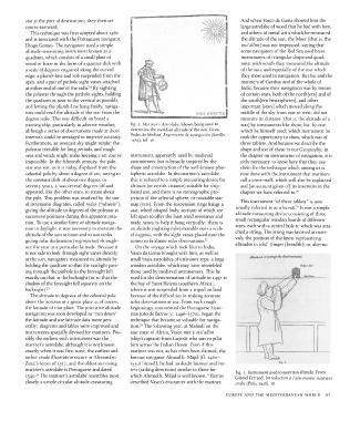
moving ship, particularly in adverse weather, fig. 2. Mariner's Astrolabe. Shown being used to star] by instruments like those, but by one
although a series of observations made at short determine the meridian altitude of the sun. From which he himself used; which instrument he
intervals could be averaged to improve accuracy. Pedro de Medina, Regimiento de navegacion (Seville, took the opportunity to show, which was of
16
1563), fol.
Furthermore, an overcast sky might render the three tablets. And because we describe the
polestar invisible for long periods, and rough shape and use of these in our Geography, in
seas and winds might make keeping a set course instrument, apparently used by medieval the chapter on instruments of navigation, it is
impossible. In the fifteenth century, the pole- astronomers, but is broadly inspired by the only necessary to know here that they use
star was not, as it is today, displaced from the shape and construction of the well-known plan- them for the technique which among us is
celestial pole by about a degree of arc; owing to ispheric astrolabe. In the mariner's astrolabe now done with the instrument that mariners
the constant shift of about one degree in this is reduced to a simple measuring device for call a cross-staff, which will also be explained
seventy years, it was several degrees off and altitude (or zenith distance) suitable for ship- and [an account given of] its inventors in the
appeared, like the other stars, to rotate about board use, and there is no stereographic pro- chapter we have referred to. 30
the pole. This problem was resolved by the use jection of the celestial sphere, or rotatable star
7
of mnemonic diagrams, called rodas ("wheels' ), map (rete). From the suspension rings hangs a This instrument "of three tablets" is now
1
giving the altitude in degrees of the polestar at cast, wheel-shaped body, sections of which are usually referred to as a kamdl? It was a simple
successive positions during this apparent rota- left open to offer the least wind resistance and altitude-measuring device consisting of three
tion. To use a similar form of altitude naviga- made heavy to help it hang vertically; there is small rectangular wooden boards of different
tion in daylight, it was necessary to measure the an alidade (sighting rule) movable over a scale sizes, each with a central hole to which was atta-
altitude of the sun at noon and to use tables of degrees, with the sight vanes placed near the ched a string. The string was knotted at inter-
giving solar declination (regimentos) through- center to facilitate solar observations. 27 vals, the position of the knots representing
out the year in a particular latitude. Because it On the voyage which took him to India, altitudes in isba' (finger [breadth]) or, alterna-
is not safe to look through sight vanes directly Vasco da Gama brought with him, as well as
at the sun, navigators measured its altitude by small brass astrolabes of unknown type, a large Meth&d'0fu*ri & the Instrument,
n
holding the quadrant so that the sunlight pass- wooden astrolabe, which may have resembled
ing through the pinhole in the foresight fell those used by medieval astronomers. This he
exactly on that in the backsight (or so that the used for the determination of latitude in 1497 at
shadow of the foresight fell squarely on the the bay of Saint Helena (southern Africa),
backsight). 25 where it was suspended from a tripod on land
The altitude in degrees of the celestial pole because of the difficulties in making accurate
above the horizon at a given place is, of course, solar observations at sea. From such rough
the latitude of that place. The primitive altitude beginnings, commented the Portuguese histo-
navigation was soon developed to "run down" rian Joao de Barros (c. 1496-1570), began the
the latitude and use latitude data more gen- technique that became so valuable for naviga-
28
erally; diagrams and tables were improved and tion. The following year, at Malindi on the
instruments specially devised for mariners. Pos- east coast of Africa, Vasco met a mu'allim
sibly the earliest such instrument was the (ship's captain) from Gujerat who was to pilot
mariner's astrolabe, although it is not known him across the Indian Ocean. Even if this
exactly when it was first used; the earliest and manner was not, as has often been claimed, the
rather crude illustration occurs in Alessandro famous navigator Ahmad b. Majid (fl. 1460-
Zorzi's letter of 1517, and the oldest surviving 1550) himself, he had no doubt learned oral rut-
Fig.
8.
mariner's astrolabe is Portuguese and dated ters (sailing directions) similar to those for fig. 3. Instrument used to ascertain altitude. From
29
26
154O. The mariner's astrolabe resembles most which Ahmad b. Majid is well known. Barros Gabriel Ferrand, Introduction a I'astronomic nautique
closely a simple circular altitude-measuring described Vasco's encounter with the mariner. arabe (Paris, 1928), 26
EUROPE AND THE MEDITERRANEAN WORLD 91