
Page 87 - Art In The Age Of Exploration (Great Section on Chinese Art Ming Dynasty)
P. 87
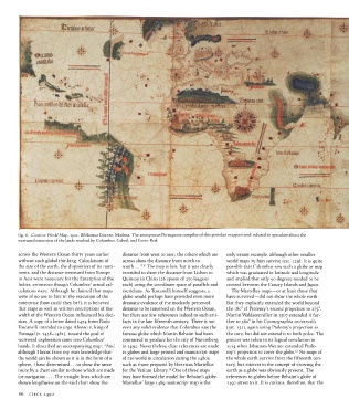
fig.  6.  Cantino  World  Map.  1502.  Biblioteca Estense, Modena. The anonymous Portuguese compiler of this portolan mappamundi  refused  to speculate about  the
          westward  extension  of the lands reached by Columbus, Cabral, and Corte-Real


          across the Western Ocean thirty years  earlier  distance from west to east;  the others which are  only extant  example,  although  other  smaller
          without  such global thinking.  Calculations of  across show the distance from  north  to  world maps by him  survive  (cat. 129).  It is quite
                                                             10
          the  size of the  earth, the  disposition of its conti-  south... "  The map is lost, but it was clearly  possible that  Columbus saw such a globe or map
          nents, and the distance westward from Europe  intended to show the distance from  Lisbon to  which was graduated in latitude and  longitude
          to Asia were necessary  for the  Enterprise of the  Quinsay in  China  (26 spaces of 250 leagues  and implied that only 90 degrees  needed to be
          Indies, erroneous though  Columbus' actual cal-  each) using the  coordinate space of parallels and  crossed between the  Canary Islands and Japan.
          culations were. Although  he claimed that maps  meridians. As Toscanelli himself suggests, a  The Martellus maps —or at least those that
          were of no use to him  in the  execution of the  globe would perhaps have provided even more  have survived — did not  show the  whole  earth.
          enterprise  (how could they be?), it is believed  dramatic evidence of the  modestly perceived  But they explicitly  extended the world  beyond
          that maps as well as written descriptions of the  distance to be traversed  on the Western  Ocean,  the  180° of Ptolemy's second projection to  275°.
          width of the  Western  Ocean influenced  his deci-  but there  are few references indeed to such arti-  Martin  Waldseemtiller in  1507 extended it fur-
          sion. A copy of a letter  dated 1474 from  Paolo  facts in the  late fifteenth  century.  There is not  ther to 360° in his  Cosmographia  universalis
          Toscanelli intended to urge Afonso v, king of  even any solid evidence that Columbus  saw the  (cat.  132), again using Ptolemy's projection as
          Portugal  (r. 1438-1481),  toward  the  goal of  famous  globe which Martin  Behaim had been  the  core, but did not extend  it to both poles.  The
          westward exploration came into Columbus'   contracted to produce for the  city of Nuremberg  process was taken to its logical conclusion in
          hands.  It described an accompanying map:  'And  in  1492.  Nevertheless, clear references  are made  1514  when Johannes Werner  extended  Ptole-
                                                                                                                            12
          although  I know from my own knowledge that  to globes and large printed and manuscript maps  my's  projection to cover the  globe.  No maps of
          the  world can be shown  as it is in the  form of a  of the  world  in circulation during the  1480$,  the whole earth  survive from  the fifteenth  cen-
          sphere,  I have determined... to show the  same  such as those prepared by Henricus Martellus  tury, but interest in the  concept of showing  the
                                                                        11
          route by a chart similar to those which are made  for  the  Vatican Library.  One  of these maps  earth  as a globe was obviously present.  The
          for  navigation  The straight lines which are  may  have formed the  model for Behaim's globe.  references  to globes before Behaim's globe of
          shown lengthwise on the  said chart show  the  Martellus' large 1489 manuscript map is the  1492 attest  to it.  It is curious, therefore, that  the

          86  CIRCA 1492