
Page 88 - Art In The Age Of Exploration (Great Section on Chinese Art Ming Dynasty)
P. 88
was at the cutting edge of geographical knowl- N O T E S
edge. Representations of the world such as his
must have catered to the taste for mathematical 1. Joan Kelly Gadol, Leon Battista Alberti: Universal
Early
Renaissance
the
Man
of
200-
(Chicago, 1969),
and cosmographical puzzles. There was a fasci- 201, usefully summarizes the debate among histo-
nation with the notion of measurement and rians such as Lynn Thorndike, Pierre Duhem, Leo
measuring instruments; maps, globes, and Olschki, Ernst Cassirer, and Alexander Koyre.
armillary spheres became graphic symbols of 2. David Woodward, "Roger Bacon's Terrestrial Coordi-
of
the Association of
scholarly learning. Later in the sixteenth cen- nate System," in Annals 80(1) 1990, 109-122.
American Geographers
tury, manuals of surveying practice and instru- 3. Here is not the place to enter into this complex
mentation became fashionable for the educated question in detail, but Ptolemy's third projection is
classes, long after such mundane pursuits had superficially similar to vanishing-point perspective,
become part of common life in the fifteenth as Samuel Y. Edgerton, Jr., "From Mental Matrix to
13
century. Likewise, the survival of Rosselli's Mappamundi to Christian Empire: The Heritage of
in the
Renaissance," in Art
Ptolemaic Cartography
simple map may well reflect an earlier broad and Cartography: Six Historical Essays, ed. David
and pervasive interest in representations of the Woodward (Chicago, 1987), 10-50, has argued,
whole earth. although the plane on which the image is projected
In fifteenth-century Europe, therefore, a fun- is not between the viewer and the object, as in Leon
damental change took place in geographical Battista Alberti's velum, but passes through the
thinking. The ideas for a measured, coherent, object. Svetlana Alpers is correct to claim that "what
is called a projection
in this cartographic
is
context
global map presented in Ptolemy's Geography never visualized by placing a plane between the
were not new, but they were received in a schol- geographer and the earth" (see Alpers, "The Map-
arly climate that valued the universality and ping Impulse in Dutch Art," in Woodward 1987, 51-
interconnectedness of knowledge. Despite the 96, especially p. 71), but there are plenty of exam-
potential of the Ptolemaic coordinate system, it ples of azimuthal projections in which this plane is
through
or passing
visualized as touching the earth
was not always fully understood at the practical it. There is a danger in pressing the similarity of
level and was certainly viewed with much sus- Ptolemy's projection to vanishing point perspective
picion by navigators hardened by experience. and inferring a cause-and-effect relationship because
Even after Gerardus Mercator showed in 1569 other azimuthal projections, such as the stereo-
that geographical coordinates and straight com- graphic, had already been in common use for astro-
Middle Ages without
a similar
labes throughout
the
pass courses could be reconciled in the same causal effect (J. V. Field, "Perspective and the Math-
14
map, the suspicion continued. But cosmo- ematicians: Alberti to Desargues," in Mathematics
graphical scholars had by then long admired and from Manuscript to Print, 1300-1600, ed. C. Hay
accepted the elegance of the global system. [Oxford, 1988]).
Navigational practice was ultimately to catch up 4. Gadol 1969, 143-211, especially 157-195. in
5.
"Medieval Mappaemundi,"
Woodward,
David
with the great hypothesis of looking at the History of Cartography: Cartography in Prehistoric,
world in global terms. Ancient, and Medieval Europe and the Mediterra-
The record presented by the maps shows an nean, eds. J. B. Harley and David Woodward (Chi-
emergence from the medieval center/periphery cago, 1987), 286-370, especially 316.
frame of mind, in which places in the world 6. Tony Campbell, "Portolan Charts from the Late
1500," in Harley
to
Century
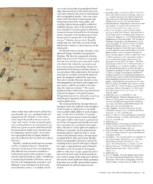
rather modest map made around 1508 by Fran- were accorded widely different levels of impor- Thirteenth 371-463, especially 386. and Wood-
ward
1987,
cesco Rosselli (cat. 133) —graduated with 360° tance. As the ideas in Ptolemy's Geography 7. Paul D. A. Harvey, "Local and Regional Cartography
longitude and 180° latitude —is the earliest took hold, the more abstract notion developed in Medieval Europe," in Harley and Woodward 1987,
extant map of the world in the pure sense of that space could be referenced to a geometrical 464-501, especially 474.
"map" and "world/ 7 It takes on special signifi- net of lines of longitude and latitude and could 8. Gadol 1969, 201.
Voyages
cance as being drawn on an oval projection into thus everywhere be accorded the same impor- 9. Richard Hakluyt, Divers the Islands Touching the ed. Dis-
Adjacent,
covery
of America and
which every point on earth could theoretically tance. The idea of a finite globe was implicit in John Winter Jones (London, 1850), 50.
be plotted and on which every potential route Ptolemy's Geography, but the projections he 10. From Columbus' copy of Cardinal Piccolomini's His-
for exploration could be shown. If ever there proposed could not explicitly show it. In the toria rerum ubique gestarum, now in the Biblioteca
was a geographical idea of elegant simplicity course of the fifteenth century, the map frame Colombina, Seville.
and Terrestrial
since the realization that the earth was a sphere, expanded little by little and at times literally 11. Jozef Babicz, "The Celestial from 1477, and Globes of
the Vatican Library, Dating
Their
this was it. burst to accommodate a discovery, such as the Maker Donnus Nicolaus Germanus (c. 1420-c.
Rosselli's coordinate world map was accompa- rounding of the Cape of Good Hope in Martel- 1490)," Der Globusfreund 35-37 (1987), 155-168.
nied by a navigation chart on a rhumb-line lus' maps. A map projection such as Rosselli's, 12. Johannes Keuning, "The History of Geographical
structure; the pairing of these two fundamen- intended to solve the puzzle of showing the Map Projections until 1600," Imago mundi 12
tally different map structures symbolizes a globe on a flat piece of paper, apparently had to (1955), 1-24.
13.
mathematical puzzle of how properly to repre- wait until the early years of the sixteenth cen- 14. Gadol 1969, 171. the Mediterranean Portu-
W. G. L. Randies, "From
sent the spherical world on a plane. Rosselli was tury. Such an image of the whole earth allowed lan Chart to the Marine World Chart of the Great
a commercial printmaker in Florence —one of the idea of a finite world over which systematic Discoveries: The Crisis in Cartography in the Six-
the first to be independently successful —and dominance was possible, and provided a power- teenth Century," Imago mundi 40 (1988), 115-118.
although he was working in one of the most ful framework for political expansion and
active humanist centers, it is unlikely that he control.
EUROPE AND THE MEDITERRANEAN WORLD 87