
Page 86 - Art In The Age Of Exploration (Great Section on Chinese Art Ming Dynasty)
P. 86
dramatically by the Corpus agrimensorum and
the Forma urbis Romae—was not apparently
sustained in the Middle Ages (although the
ninth-century Plan of Saint Gall is an obvious
exception). The rediscovered importance of rep-
resenting cities in measured proportion is strik-
ingly shown by comparing fourteenth-century
city views, in which the position of buildings is
shown topologically, with the scaled plan of
Vienna and Bratislava, the content of which
dates to 1421-1422. 7
For geography, cartography, and the associ-
ated practical mathematical arts in the western
world, therefore, the fifteenth century was cru-
cial in forming "the first coherent, and ration-
ally cumulative pictures of the world since
78
antiquity/ A key ingredient was that a transi-
tion took place in the way people viewed the
world, from the circumscribed cage of the
known inhabited world to the notion of the
finite whole earth. The transition began with fig. 4. Hermann Wagner, Reconstruction of Toscanelli's Map, "Die Rekonstruktion der Toscanelli-Karte vom
the concepts of the universality and intercon- Jahre 1474 " From Nachrichten der K. Gesellschaft der Wissenschaften zu Gottingen, Phil. Hist. Kl.
nectedness of knowledge, neo-Platonic ideas (1894), 313
that the circle of thinkers that included Leon
9
Battista Alberti, Paolo Toscanelli, and Nicolas of spherical earth, a tabula rasa on which the lande inhabitable nor sea innavigable/' The cir-
Cusa was to share. For geography, this meant a achievements of exploration could be cumula- cumnavigation of the world in 1522 had made
movement away from local topological concepts tively inscribed. Robert Thorne, merchant and everything possible.
toward those of a finite, spatially referenced geographer, boasted in 1527 that "there is no Columbus could not have made his voyage
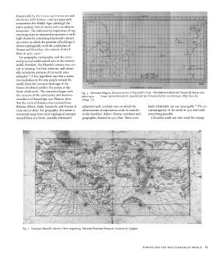
fig. 5. Francesco Rosselli, Marine Chart, engraving. National Maritime Museum, Greenwich, England
EUROPE AND THE MEDITERRANEAN WORLD 85