
Page 85 - Art In The Age Of Exploration (Great Section on Chinese Art Ming Dynasty)
P. 85
(cats. 126, 127), establishing Ptolemy's prime strably a community of scholarship and practice
authority as a geographer. that grew up later in the fifteenth century
The practical application of the idea of coordi- around the idea of measured space. There was a
nates for geographical maps did not take effect common interest in geometrically proportioned
either in the Islamic or the western world until representations of nature among artists and
sufficient observations had been gathered and a engineers of the fifteenth century that is the
clear need was felt. Thus, despite Bacon's impas- hallmark of the "universal man" of the Renais-
4
sioned plea that a framework of locations was sance. Surveying and mapping the earth were
essential "for the conversion of unbelievers and at the very heart of this activity. Similar instru-
for opposing unbelievers and the Antichrist and ments were designed for observing angles and
others," neither the data nor the demand were distances in astronomy (see cats. 120, 123),
ready for the concept. 2 artillery range finding, building construction,
Ptolemy explained that his proposed scheme land surveying, and navigation. Methods of
of mapping places by their longitude and lati- calculating the position of inaccessible points
tude was intended to preserve the correct pro- using similar and congruent triangles were
portion of small areas (chorography) to the developed as the precursors of triangulation.
whole earth (geography), working as a painter One result for cartography of this infatuation
might sketch in the broad strokes before filling with measurement was the blending of carto-
0 10,000 20.000 30,000 <0,000 Stades
in the detail. The abstract, numbered graticule graphic traditions that had remained distinct in
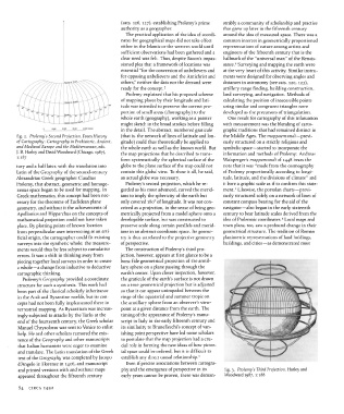
fig. 2. Ptolemy's Second Projection. From History (that is, the network of lines of latitude and lon- the Middle Ages. The mappaemundi — previ-
of Cartography: Cartography in Prehistoric, Ancient, gitude) could thus theoretically be applied to ously structured on a strictly religious and
and Medieval Europe and the Mediterranean, eds. the whole earth as well as the known world. But symbolic space — started to incorporate the
J. B. Harley and David Woodward (Chicago, 1987), the map projections that he described to trans- information and methods of Ptolemy: Andreas
1:187
form systematically the spherical surface of the Walsperger's mappamundi of 1448 bears the
tury and a half later, with the translation into globe to the plane surface of the map could not note that it was "made from the cosmography
Latin of the Geography of the second-century contain this global view. To show it all, he said, of Ptolemy proportionally according to longi-
Alexandrian Greek geographer Claudius an actual globe was necessary. tude, latitude, and the divisions of climate" and
Ptolemy, that abstract, geometric and homoge- Ptolemy's second projection, which he re- it bore a graphic scale as if to confirm this state-
5
neous space began to be used for mapping. In garded as his most advanced, curved the merid- ment. Likewise, the portolan charts — previ-
Greek mathematics, this concept had been nec- ians to imply the sphericity of the earth but ously structured solely on a network of lines of
essary for the theorems of Euclidean plane only covered 180° of longitude. It was not con- constant compass bearing for the aid of the
geometry, and without it the achievements of ceived as a projection, in the sense of being geo- navigator —also began in the early sixteenth
Apollonius and Hipparchus on the concepts of metrically projected from a model sphere onto a century to bear latitude scales derived from the
6
mathematical projection could not have taken developable surface, but was constructed to idea of Ptolemaic coordinates. Local maps and
place. By plotting points of known location preserve scale along certain parallels and merid- town plans, too, saw a profound change in their
from perpendicular axes intersecting at an arti- ians in an abstract coordinate space. Its geome- geometrical structure. The tradition of Roman
ficial origin, the cartographer could fit existing try is thus unrelated to the projective geometry planimetric representations of land holdings,
surveys into the synthetic whole; the measure- of perspective. buildings, and cities — as demonstrated most
ments would thus be less subject to cumulative The construction of Ptolemy's third pro-
errors. It was a shift in thinking away from jection, however, appears at first glance to be a
piecing together local surveys in order to create bona fide geometrical projection of the armil-
a whole — a change from inductive to deductive lary sphere on a plane passing through the
cartographic thinking. earth's center. Upon closer inspection, however,
Ptolemy's Geography provided a coordinate the graticule of the earth's surface is not drawn
structure for such a synthesis. This work had on a true geometrical projection but is adjusted
been part of the classical scholarly inheritance so that it can appear unimpeded between the
in the Arab and Byzantine worlds, but its con- rings of the equatorial and summer tropic on
cepts had not been fully implemented there in the armillary sphere from an observer's view-
terrestrial mapping. As Byzantium was increas- point at a given distance from the earth. The
ingly subjected to attacks by the Turks at the timing of the appearance of Ptolemy's manu-
end of the fourteenth century, the Greek scholar script in Italy in the early fifteenth century and
Manuel Chrysoloras was sent to Venice to enlist its similarity to Brunelleschi's concept of van-
help. He and other scholars rumored the exis- ishing point perspective have led some scholars
tence of the Geography and other manuscripts to postulate that the map projection had a cru-
that Italian humanists were eager to examine cial role in forming the new ideas of how pictor-
and translate. The Latin translation of the Greek ial space could be ordered, but it is difficult to
text of the Geography was completed by Jacopo establish any direct causal relationship. 3
dAngelo in Florence in 1406, and manuscript Even if precise associations between cartogra-
and printed versions with and without maps phy and the emergence of perspective in its fig. 3. Ptolemy's Third Projection. Harley and
appeared throughout the fifteenth century early years cannot be proven, there was demon- Woodward 1987,1:188
84 CIRCA 1492