
Page 91 - Art In The Age Of Exploration (Great Section on Chinese Art Ming Dynasty)
P. 91
folklore of two traditions, that of the west- bowl of water. There is a thirteenth-century and its island archipelagos were equipped with
facing Atlantic coast and that of the "inland Arabic description of the use of such a compass compasses and gradually with coastal sailing
sea/' the Mediterranean, from which sailors on a voyage from Tripoli (Lebanon) to Alexand- directions and charts, as well. They would not
rarely ventured voluntarily into the Atlantic. ria, but by the end of the twelfth century, the voluntarily have sought to sail far from land. 22
During antiquity and the early Middle Ages, English writer Alexander Neckam had already The political, religious, and economic factors
sailing in the virtually tideless Mediterranean referred to the use of the compass at sea, and to that pushed the Europeans to explore the west
was concentrated in the summer months and a needle placed on a pivot. He is followed in the coast of Africa as a possible entry to the fabled
was mostly coastal or "island hopping/' It thirteenth century by references in the works of tropical Africa are beyond the scope of this
required an ability to judge the speed of the ship Guy de Provins, Jacques de Vitry, and King essay, but the distinction must be made between
15
and to estimate distance, a knowledge of sea- Alfonso x, the Wise (el sabio), of Castile, and fortuitous or involuntary discovery and deliber-
sonal wind directions and their relationship to most notably in the famous treatise of Petrus ate voyaging for power or financial gain, imply-
ports of departure and destination, visibility and Peregrinus de Maricourt, the Epistola de mag- ing colonization. The Portuguese, who
identification of the polestar, and the use of lead nete of 1269. developed a fishing monopoly in the African
and line to avoid shoals and to sample the By the fifteenth century, the compass had Atlantic, were backed by policies at home. "O
seabed as a means of determining locations. 16 been greatly improved for nautical use by the plantador de naus" (the planter of ships), the
A transformation of basically coastal naviga- substitution of the "fly" for the simple pivoted poet Fernando Pessoa called King Diniz of Por-
tion, whether in the Mediterranean or off the needle. A fly is a disk of pasteboard under tugal (ruled 1279-1325), who around 1300
Atlantic coasts of Europe, into a technique that which is attached the needle (or a metal frame) ordered the planting of the pine forest of Leiria,
would permit venturing out of sight of land in and its pivot cup; the diameter of the disk is which later supplied wood for the royal ship-
the open ocean, with the expectation of return such as to make it move closely within the con- yards. In 1415, the Portuguese took Ceuta; in
23
to the port of departure, requires an ability to fines of the compass-box. The disk was painted 1434, under Gil Eanes, they passed Cape Boja-
determine position on the globe accurately, in with the design and lines of the wind- and com- dor, probably preceded by the Vivaldi brothers
modern terms, to be able to find the ship's lati- pass-roses familiar from early sea charts and in 1291 — Genoese merchants who apparently
tude and longitude in a coordinate system. This bore a circumferential scale of degrees and eight perished in the first recorded European voyage
transformation is as much sociological as tech- "winds," subdivided into "quarter winds" of to the Indies —and others after them. From this
nological. Any early astronomer, for instance eleven and one quarter degrees each. The trans- date the voyages there and beyond become reg-
Ptolemy of Alexandria (c. A.D. 150) or az-Zar- ference of the scale from the rim surrounding ular, and that required a solution of the prob-
qellu (Arzachiel) in eleventh-century Toledo, the needle to the fly made possible a direct lems of returning to Portugal. These problems
19
could have instructed a sailor in the use of an reading of a course to be set. Possibly the ear- arose from the nature of the winds and currents
astrolabe to find his latitude at sea but, practical liest detailed illustration of a compass with a fly in the Atlantic off the Guinea coast, which
difficulties apart, the question would not have is the allegorical drawing by Leonardo da Vinci, forced returning ships to sail into the open sea
been asked, because sailors belonged to a craft dated about 1515-1516 (cat. 189), in which a in a wide northwestward arc. To reach Lisbon,
and so did not mingle with learned astrono- wolf, seated in a sailing boat, is looking at a or any other Portuguese port, while sailing
mers. The traditions of classical, Byzantine, and fixed compass that clearly has a fly. The ship's northwards, the mariners observed the altitude
Islamic craft navigation in the Mediterranean, course would have been set first according to (angle above the horizon) of the polestar until
and the contemporary navigation on the Atlan- "wind" directions given in written sailing direc- its observed altitude matched that of the pole-
20
tic coast, were, in fact, eventually developed by tions, and later according to the rhumb lines
three infusions of "scientific" and "technolog- drawn on the sea charts, which were in use by
21
ical" knowledge. The first of these occurred in the end of the thirteenth century. The rhumb
the late twelfth and thirteenth centuries with lines radiated from wind- or compass-roses and
the introduction of the marine (magnetic) com- showed directions from port to port across the
17
pass and the creation of sea charts, using a Mediterranean. If, for example, a ship's master
network of lines that enabled courses to be set wished to sail from Tunis to Genoa, inspection
using the compass to navigate by azimuth. The of a chart would show that the angle from the
second took place during the fifteenth and early meridian (the north-south line) was so many
sixteenth centuries, when a form of astro- degrees or "quarter winds"; then, with the
nomical navigation was evolved, enabling lati- compass placed in a case, called a binnacle, with
18
tude to be determined. The third important its north-south line aligned on the longitudinal
development came in the eighteenth century, axis of the ship, the master would seek to sail
when the invention of the marine chronometer keeping the fly positioned so that the appropri-
provided a practical method of finding a ship's ate angle marked on it remained opposite the
longitude. fiducial mark on the compass box.
The use of lodestone, or a needle magnetized This combination of marine compass and sail-
by it, to determine direction derives from ing directions or sea chart constitutes the first
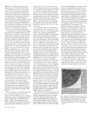
China, but how knowledge of its use was trans- important technological advance in navigation fig. i. Quadrant. Two sight-vanes are shown on the
mitted remains obscure, although presumably it beyond the traditional Mediterranean tech- top radial edge. Near the apex is a diagram of unequal
passed through Islam, to medieval Christian niques, scarcely changed since antiquity. The hours and possibly a solar declinations scale, which
Europe. A stage in the development of the French, Italian, Spanish, Catalan, and Portu- enabled the quadrant to be used as a sundial. From
marine compass was the technique of floating a guese navigators who, from the late thirteenth Valentim Fernandes, Reportorio dos tempos (Lisbon,
magnetized needle embedded in a straw on a century, explored down the west coast of Africa 1563), 140
90 CIRCA 1492