
Page 10 - Plants+ of the Black Range Vol. 2
P. 10
Sawyers Peak Trail: From Emory Pass, the Black Range Crest Trail heads south, first to Sawyers Peak and then on even farther south along the crest. Among those who have collected in this area is O. B. Metcalfe (1901-1905).
Iron Creek Campground: E. F. Castetter (1939-1954), O. B. Metcalfe (1901-1905), T. H. Nash III (1973), Russ Kleinman (2009-2018), and K. Blisard (2011-2018) have all collected in this area. West from Emory Pass, NM-152 first passes Wright’s Cabin, there are several canyons which are accessible in this general area.
Gallinas Canyon (Upper and Lower Gallinas
Campgrounds): Richard D. Worthington (1983-1998), R. Fletcher (1977-1985), David M. Studhalter (1934), Robert Sivinski (1993-2018), T. K. Todsen (1969), Russ Kleinman (2009-2018), K. Blisard (2011-2018), and Tim Thibault (2016) are some of the individuals who have collected in this area.
Royal John Mine Road: The Royal John Mine Road starts on NM-61 along the Mimbres River and climbs eastward to the (among other places) upper reaches of Silver Creek. G. Rink (2016) collected in this area.
City of Rocks State Park
San Lorenzo: Raymond C. Jackson, Eugene M. Jercinovic (2009-2010), Robert C. Sivinski (1993-2018), Charles W. Irish (1878), R. D. Worthington (1983-1998), and Kenneth D. Heil (1998-2012) are some of those who have collected in this area. San Lorenzo is a small community on the Mimbres River and offers a variety of habitats to explore.
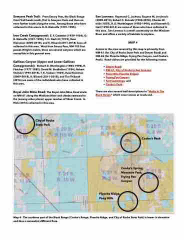
MAP 4
Access to the area covered by this map is primarily from NM-61 (for City of Rocks State Park and Dwyer Road) and NM-26 (for Fluorite Ridge, Frying Pan Canyon, and Cooke’s Peak). Road videos are provided for the following routes:
• Dwyer Road;
• NM-61, City of Rocks to San Lorenzo; • Pony Hills (Fluorite Ridge);
• Frying Pan Canyon;
• Fort Cummings; and
• Cooke’s Peak.
There are also several trail descriptions in “Walks In The Black Range” which cover access at roads end.
Cooke’s Peak
Cooke’s Spring, Massacre Pass, Frying Pan Canyon
Fluorite Ridge, Pony Hills
Map 4. The southern part of the Black Range (Cooke’s Range, Fluorite Ridge, and City of Rocks State Park) is lower in elevation and thus a somewhat different flora.
