
Page 256 - Proceeding of Atrans Young Researcher's Forum 2019_Neat
P. 256
“Transportation for A Better Life:
Smart Mobility for Now and Then”
23 August 2019, Bangkok, Thailand
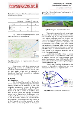
sector. Fig. 9 shows the image of implementation of
Table. 2 Prioritization of implementation measure to elevated arterial roads.
inundated road sections
VCR
0.00-0.50 0.50-0.70 0.70-1.00
1-2 L L M
Freqency of Floods 3-4 L M H
5-6 M H H Fig.9 The Image of elevated arterial roads
The simulation results for each scenario are
Fig. 8 shows that the priority obtained by the shown in Fig. 10, and Fig. 11. The thickness of the
above method on the road network. road sections in Fig. 10, and Fig. 11 represents the
traffic volume each road sections. It is found that
there is a lot of traffic in the east road section when
measures are not taken against road disruptions. On
the other hand, there is a lot of traffic in the eastern
road sections in without case. In Fig. 10, the leading
road network between the northern and the southern
part of the city is cut off by inundation. Hence, the
traffic volume of the network in the eastern part of
the city has been increased.
Additionally, the traffic volume of eastern
road sections is about 24,400 vehicles in "with" case.
In "without" case, the traffic volume on the same
section has decreased about 1,600 vehicles. This
Fig. 8 Prioritization of implementation of measure reason is that most traffic passed through the by-pass
on road sections roads of the eastern part.
Thus, it was found that implementing the
Road sections which show red colors are the measures on high priority road sections lead to an
high priority sections. In consideration of traffic increase in the effects of its implementation.
volume, it could be clarified the road section, which
has high traffic volume and is vulnerable to
inundation. Therefore, it is possible to implement
measures preferentially.
4. Results
4.1 Simulation
We simulated the scenario of the baseline
and the scenario of implement adaptation measure as
follows. For minimizing the effects of floods, the
adaptation measures are proposed in the existing
studies which are classified into hard and soft (e.g.,
Stamos et al. (2015), Madan, et al. (2015)). From Fig. 10 Result of simulation (without case)
these existing studies, we selected the elevated
arterial road for alleviating the flood damages on the
road network. The reason for choosing this measure
is that The Elevated arterial road was implemented
the eastern belt highway (National Highway No. 9)
in the Bangkok metropolitan area after an urban
flood in 2011 for alleviating effects on the transport
231