
Page 70 - Eden Meadow 35 houses application as of 12 October
P. 70
PART B- ADDENDUM
SITE LAYOUT PLAN
Feedback from the consultation period during the application
focused on changing the concept so that the parcel works as a stand
alone site. This in turn required a reconsideration of the layout with
a move to more of a perimeter block so that the proposals would
respond positively to the edges of the site.
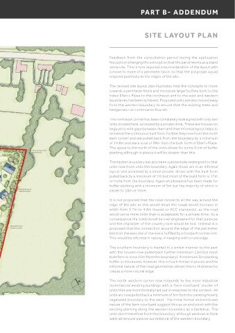
The revised site layout plan illustrates how the concepts to move
towards a perimeter block and introduce larger buffers both to the
listed Ellen’s Place to the northeast and to the east and western
boundaries has been achieved. Proposed units are also moved away
from the western boundary to ensure that the existing trees and
hedgerows can continue to flourish.
The northeast corner has been completely redesigned with only two
units located here, accessed by a private drive. These are houses on
large plots with gaps between them and their informal layout helps to
minimise the continuous built form. Further they now front the north
east corner and are pulled back from the boundary by a minimum
of 14.8m and are a total of 98m from the built form of Ellen’s Place.
The space to the north of the units allows for some 9.5m of buffer
planting although in places it will be deeper than this.
The eastern boundary has also been substantially redesigned so that
units now front onto this boundary. Again these are in an informal
layout and accessed by a small private, drives with the built form
pulled back by a minimum of 7m but most of the build form is 17m
or more from the boundary. Again an allowance has been made for
buffer planting with a minimum of 5m but the majority of which is
closer to 10m or more.
It is not proposed that the road connects all the way around the
edge of the site as this would mean the roads would increase in
width from 3.7m to 4.8m (based on KCC standards), as the road
would serve more units than is acceptable for a private drive. As a
consequence the roads would be over engineered for their purpose
and the character of the country lane would be lost. Instead it is
proposed that the connection around the edge of the perimeter
block on the east site of the site is fulfilled by a footpath connection.
This would be informal in nature, in keeping with a rural edge.
The southern boundary is treated in a similar manner to the east
with the houses now pulled back further (minimum 12m but most
built form is circa 15m from the boundary). A minimum 5m planting
buffer is introduced, however, this is much thicker in places and the
informal nature of the road geometries allows this to thickened to
create a more natural edge.
The north-western corner now responds to the more industrial
/commercial existing buildings with a ‘farm courtyard’ cluster of
units that are more formally laid out in response to the context. All
units are now pulled back a minimum of 5m from the existing heavily
vegetated boundary to the west. The more formal and enclosed
nature of the farm courtyard suggest this as an end point with the
existing planting along the western boundary as a backdrop. The
v units don’t therefore front this boundary, although windows in flank
walls will ensure passive surveillance of the western boundary.