
Page 8 - 3. References
P. 8
REFERENCES 3
Rapid City, South Dakota
HYDROLOGIC AND HYDRAULIC MODELING AND INUNDATION MAPPING
FOR HAINES AVENUE DRAINAGE, ROBBINSDALE DRAIN, AND SOUTH CANYON CREEK
FEMA remapped Rapid City in adjusting model inputs based on analysis to determine if the potential
2012 and defined Base Flood Elevations the complex Black Hills geology, improvements provided enough benefit to
on a number of drainages throughout and calibrating the hydrologic be cost-effective. This portion of the work
the City that had not previously been models to observed peak is ongoing.
defined. However, FEMA used extremely discharges in one of the basins.
conservative flow estimates to define the • New floodplain / floodway maps
floodplain extents along the drainages and for all three drainages including DATE
placed numerous residential structures breakout reaches. The remapped 2016 CLIENT
within the regulatory floodplain because floodplains included over 6.5 PROJECT COSTS City of Rapid City, SD
of the overly conservative flow estimates. miles of stream reaches $267,000 CLIENT CONTACTS
AE2S recently submitted Letters of • New static pool Base Flood Mary Bosworth, PE, CFM
Map Revisions for the Haines Avenue, Elevation definition for Floodplain / Drainage
Engineer
Robbinsdale Drain, and South Canyon three detention areas in the 605-394-4154
Creek flooding sources – a mere four short Robbinsdale Drain watershed.
months after project kick-off. • Revising 10 different FIRM
Included in the project was: panels KEY PROJECT ELEMENTS
• Extensive field surveying of In addition to the extensive floodplain • Surveying
channel cross sections, bridges, remapping, the City also contracted • Hydrologic Modeling
and culverts within the SFHA with AE2S to evaluate watershed and • HEC-RAS 5.0 Hydraulic Modeling
along with numerous culverts floodplain improvements that could • Flood Inundation Mapping
• Flood Risk Planning
• New watershed rainfall-runoff remove the remapping structures from the
models (HMS and SWMM), floodplain and to perform a cost-benefit
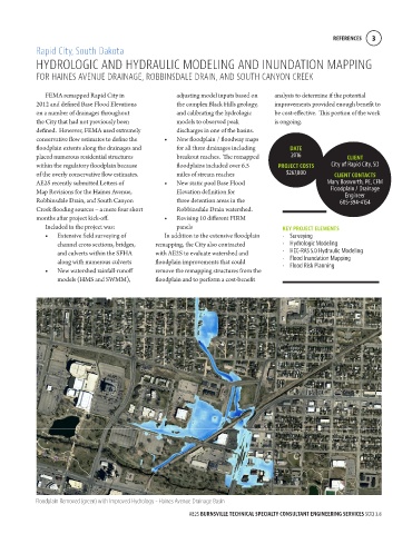
Floodplain Removed (green) with Improved Hydrology - Haines Avenue Drainage Basin
AE2S BURNSVILLE TECHNICAL SPECIALTY CONSULTANT ENGINEERING SERVICES SOQ 3.8