
Page 647 - PPL-engelsk 2025
P. 647
Flight performance and planning
As a pilot, you must quickly assess whether there is a need to change the route.
It could be that the route was too close to a restricted area or active gliding
airfield. That is not the case here. But we will be close to Fasterholt and Arnborg,
where cable launching of gliders and paragliders up to 2500 feet is ongoing! So,
we must keep a close look out when passing the sites.
The route is measured partly in terms of True Track (TT) and distances.
The values found are entered into the operational flight plan.
You can download an operational flight plan here: Driftflyveplan.pdf
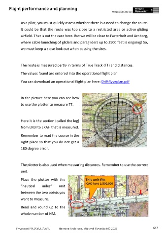
In the picture here you can see how
to use the plotter to measure TT.
Here it is the section (called the leg)
from EKBI to EKAH that is measured.
Remember to read the course in the
right place so that you do not get a
180 degree error.
The plotter is also used when measuring distances. Remember to use the correct
unit.
Place the plotter with the
“nautical miles” unit
between the two points you
want to measure.
Read and round up to the
whole number of NM.
Flyveteori PPL(A)(UL)/LAPL Henning Andersen, Midtjysk Flyveskole© 2025 647