
Page 817 - PPL-engelsk 2025
P. 817
Navigation
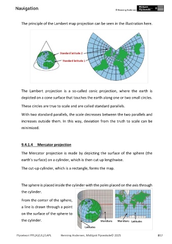
The principle of the Lambert map projection can be seen in the illustration here.
The Lambert projection is a so-called conic projection, where the earth is
depicted on a cone surface that touches the earth along one or two small circles.
These circles are true to scale and are called standard parallels.
With two standard parallels, the scale decreases between the two parallels and
increases outside them. In this way, deviation from the truth to scale can be
minimized.
9.4.1.4 Mercator projection
The Mercator projection is made by depicting the surface of the sphere (the
earth's surface) on a cylinder, which is then cut up lengthwise.
The cut-up cylinder, which is a rectangle, forms the map.
The sphere is placed inside the cylinder with the poles placed on the axis through
the cylinder.
From the center of the sphere,
a line is drawn through a point
on the surface of the sphere to
the cylinder.
Flyveteori PPL(A)(UL)/LAPL Henning Andersen, Midtjysk Flyveskole© 2025 817