
Page 852 - PPL-engelsk 2025
P. 852
Navigation
9.7.5 Practical use
Now all 3 legs have been measured (True Track and Distance) and entered into
a table:
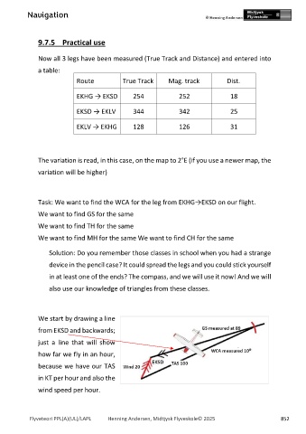
Route True Track Mag. track Dist.
EKHG → EKSD 254 252 18
EKSD → EKLV 344 342 25
EKLV → EKHG 128 126 31
The variation is read, in this case, on the map to 2°E (if you use a newer map, the
variation will be higher)
Task: We want to find the WCA for the leg from EKHG→EKSD on our flight.
We want to find GS for the same
We want to find TH for the same
We want to find MH for the same We want to find CH for the same
Solution: Do you remember those classes in school when you had a strange
device in the pencil case? It could spread the legs and you could stick yourself
in at least one of the ends? The compass, and we will use it now! And we will
also use our knowledge of triangles from these classes.
We start by drawing a line
from EKSD and backwards;
just a line that will show
how far we fly in an hour,
because we have our TAS
in KT per hour and also the
wind speed per hour.
Flyveteori PPL(A)(UL)/LAPL Henning Andersen, Midtjysk Flyveskole© 2025 852