
Page 415 - Mechatronics with Experiments
P. 415
October 9, 2014 8:1
Printer: Yet to Come
JWST499-c06
JWST499-Cetinkunt
SENSORS 401 254mm×178mm
y
Object location
(x,y,z) coordinates
Satellite
Satellite Satellite A Satellite
C
A C
Object location
(x,y)
Satellite
B
Satellite Earth serves as
B
the fourth spherical data
reference to determine
"the point" (x,y,z)
intersection
x
(a) (b)
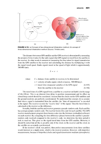
FIGURE 6.72: (a) Concept of two-dimensional trilateration method, (b) concept of
three-dimensional trilateration method (Source: Trimble.com).
The distance between a GPS satellite and the GPS receiver is determined by measuring
the amount of time it takes for the radio signal (the GPS signal) to travel from the satellite to
the receiver. In other words it amounts to measuring the time taken for signal transmission
from the GPS satellite to the receiver and calculating the distance by multiplying it with
the signal travel speed. Radio signals travel at the speed of light which is approximately
300 000 km/s.
S = ⋅ t
where S = distance from satellite to receiver, to be determined
= velocity of radio signal, which is known, 300 000 km∕s
t = travel time (measured variable) of the GPS signal (6.195)
from the satellite to the receiver (6.196)
The travel time of a GPS signal from a satellite to a receiver on Earth is in the range
of 60–100 ms. This is an inherent time delay in position measurement and its effect on
closed loop control should be considered. Assume that the clocks on the GPS satellites and
the ground receivers are perfectly synchronized. To understand the concept, let us assume
that when a signal is transmitted from the satellite, the “time of transmission” is encoded
in the signal. The receiver records the “receive time” of the signal. Then the travel time is
calculated at the receiver as the difference.
In reality, both the satellite and receiver generate a pseudo-random code. Each satellite
has a unique pseudo-random code. The receiver knows this code for each satellite. The GPS
receiver manufacturers program these known codes into the firmware (embedded software)
on each receiver. By comparing the time difference (phase) between the satellite’s pseudo-
random code received compared to the receiver’s code, we determine the time period it
took to reach us. This gives us the signal travel time from the GPS satellite. However, it
should be noted that all this is possible only if the clock on the receiver and the clock on
the satellite are accurately synchronized.
If the receiver’s clock was perfect, then perfect measurements from three satellites
would intersect at a single point, which is the receiver position. However, with imperfect
measurements, because of imperfect clocks and signal transmission medium (atmospheric)