
Page 412 - Mechatronics with Experiments
P. 412
JWST499-Cetinkunt
JWST499-c06
398 MECHATRONICS Printer: Yet to Come October 9, 2014 8:1 254mm×178mm
Z
Pole GPS Receiver:
Elevation - Longitude
- Latitude
- Elevation
Earth
surface
Equator Latitude
Y
Longitude
X
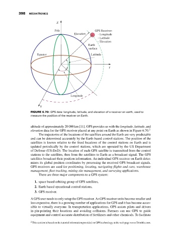
FIGURE 6.70: GPS data: longitude, latitude, and elevation of a receiver on earth, used to
measure the position of the receiver on Earth.
altitude of approximately 20 000 km [11]. GPS provides us with the longitude, latitude, and
elevation data for the GPS receiver placed at any point on Earth as shown in Figure 6.70. 2
The trajectories of the locations of the satellites around the Earth are very predictable
and can be determined accurately by the Earth-based control stations. The position of the
satellites is known relative to the fixed locations of the control stations on Earth and is
updated periodically by the control stations, which are operated by the US Department
of Defense (US-DoD). The location of each GPS satellite is transmitted from the control
stations to the satellites, then from the satellites to Earth as a broadcast signal. The GPS
satellites broadcast their position information. An individual GPS receiver on Earth deter-
mines its global position coordinates by processing the received GPS broadcast signals.
GPS receivers are used for positioning, locating, navigating flights and cars, warehouse
management, fleet tracking, mining site management, and surveying applications.
There are three major components to a GPS system:
1. space based orbiting group of GPS satellites,
2. Earth based operational control stations,
3. GPS receiver.
A GPS user needs to only setup the GPS receiver. As GPS receiver units become smaller and
less expensive, there is a growing number of applications for GPS and it has become acces-
sible to virtually everyone. In transportation applications, GPS assists pilots and drivers
in pin-pointing their locations and avoiding collisions. Farmers can use GPS to guide
equipment and control accurate distribution of fertilizers and other chemicals. To facilitate
2 This section is based on the tutorial information provided on GPS technology at the web page www.Trimble.com.