
Page 289 - Atlas Sea Birds Ver1
P. 289
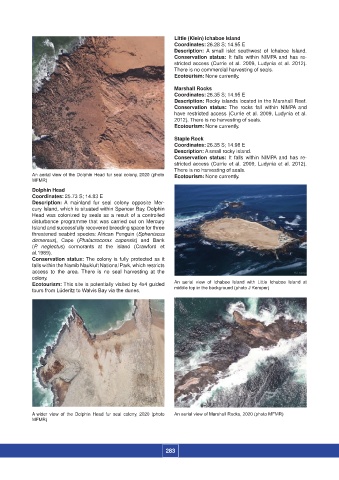
Little (Klein) Ichaboe Island
                                                                    Coordinates: 26.28 S; 14.95 E
                                                                    Description:  A  small  islet  southwest of  Ichaboe  Island.
                                                                    Conservation status:  It  falls within  NIMPA and  has re-
                                                                    stricted access (Currie et al. 2009, Ludynia et al. 2012).
                                                                    There is no commercial harvesting of seals.
                                                                    Ecotourism: None currently.
                                                                    Marshall Rocks
                                                                    Coordinates: 26.35 S; 14.95 E
                                                                    Description: Rocky islands located in the Marshall Reef.
                                                                    Conservation status:  The rocks fall  within  NIMPA  and
                                                                    have restricted access (Currie et al. 2009, Ludynia et al.
                                                                    2012). There is no harvesting of seals.
                                                                    Ecotourism: None currently.

                                                                    Staple Rock
                                                                    Coordinates: 26.35 S; 14.98 E
                                                                    Description: A small rocky island.
                                                                    Conservation status:  It  falls within  NIMPA and  has re-
                                                                    stricted access (Currie et al. 2009, Ludynia et al. 2012).
                                                                    There is no harvesting of seals.
                  An aerial view of the Dolphin Head fur seal colony, 2020 (photo  Ecotourism: None currently.
                  MFMR)
                  Dolphin Head
                  Coordinates: 25.73 S; 14.83 E
                  Description:  A  mainland  fur  seal colony opposite Mer-
                  cury Island, which is situated within Spencer Bay. Dolphin
                  Head was colonized by seals as a result of a controlled
                  disturbance programme that was carried out on Mercury
                  Island and successfully recovered breeding space for three
                  threatened seabird species: African Penguin (Spheniscus
                  demersus),  Cape  (Phalacrocorax capensis)  and  Bank
                  (P. neglectus)  cormorants  at  the  island  (Crawford  et
                  al.1989).
                  Conservation status: The colony is fully protected as it
                  falls within the Namib Naukluft National Park, which restricts
                  access to the area.  There is no seal harvesting at the
                  colony.
                  Ecotourism: This site is potentially visited by 4x4 guided   An  aerial  view of  Ichaboe Island with  Little Ichaboe Island at
                  tours from Lüderitz to Walvis Bay via the dunes.  middle top in the background (photo J Kemper)


                  A wider view  of the Dolphin  Head  fur seal  colony, 2020  (photo   An aerial view of Marshall Rocks, 2020 (photo MFMR)
                  MFMR)


                                                                 283