
Page 287 - Atlas Sea Birds Ver1
P. 287
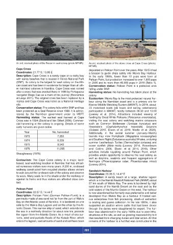
An old, stocked photo of the Toscanini seal colony (photo MFMR)  An old, stocked photo of the stone cross at Cape Cross (photo)
                                                                    MFMR)
                  Cape Cross                                        deposited on Pelican Point over the years. After 1915 it had
                  Coordinates: 21.77 S; 13.95 E                     a beacon to guide ships safely into Walvis Bay Harbour.
                  Description: Cape Cross is a sandy cape on a rocky bay   In  the  early 1990s, fewer than 10 pups  were  born  at
                  with sandy beaches that is located in Dorob National Park   Pelican Point, but production increased to over 1,600 pups
                  (DNP). Its colony is the largest fur seal colony on the Afri-   in 2006 and to more than 40,000 pups in 2018 (Table 1).
                  can coast and has been in existence for longer than all oth-   Conservation status:  Pelican  Point is a protected area
                  er mainland colonies in Namibia. Cape Cross was named   falling under DNP.
                  after a cross that was erected there in 1486 by Portuguese   Harvesting status: No harvesting has taken place at the
                  navigator Diego Cao as a mark of his journey (Economics   colony.
                  at Large 2011). The original cross has been replaced by a   Ecotourism: Walvis Bay is the most protected natural har-
                  replica and Cape Cross was listed as a National Heritage   bour  along  the Namibian  coast and  is a primary site for
                  site.                                             Marine Wildlife Watching Tourism (MWWT). In 2014, about
                  Conservation status: The colony falls within DNP and has   23  motorised  boats  (ski  boats  and  sailing  catamarans)
                  been protected as a Seal Reserve since 1968. It is admin-   participated  in MWWT,  mostly between 08:30 and 13:00
                  istered by  the Namibian government under its  MEFT.   (Leeney  et  al.  2014).  Attractions  included  viewing  of
                  Harvesting  status:  The  earliest  seal  harvest  at  Cape   feeding by Great White Pelicans (Pelecanus onocrotalus),
                  Cross was in 1924 (David and Van Sittert 2008). Commer-   visiting  the  seal  colony and  watching marine cetaceans
                  cial harvesting at the colony is ongoing. Details of some   such as Common  Bottlenose (Tursiops truncatus)  and
                  early harvests are given below.                   Heaviside’s  (Cephalorhynchus  heavisidii)   Dolphins
                                                                    (Golaski  2015,  Elwen  et  al.  2019,  Martin  et  al.  2020).
                        Year               No. harvested            Additionally,  in  the  austral  summer  (January–March)
                       1973                   7,353                 tourists may view Humpback  (Megaptera  novaeangliae)
                       1974                   6,339                 and Southern Right (Eubalaena australis) Whales, or during
                                                                    summer Leatherback Turtles (Dermochelys coriacea) and
                       1975                   9,543                 ocean  sunfish  (Mola mola)  (Leeney  2014,  Rosenbaum
                       1976                   11,095                and  Collins  2006,  Elwen  et  al.  2014,  2019).  Other
                                                                    activities  include kayaking  around  Pelican  Point,  which
                  Shaughnessy (1978)
                                                                    provides ample opportunity to observe the seal colony as
                                                                    well  as dolphins, seabirds  and frequent aggregations  of
                  Ecotourism:  The Cape Cross  colony is a major,  land-   flamingos  (Phoenicopterus  ruber,  Phoeniconaias  minor)
                  based, seal-watching location in Namibia that has attract-   (Leeney 2014).
                  ed numerous visitors over many years. A 200 m, enclosed
                  walkway constructed from recycled plastics allows visitors   Sandwich Harbour
                  to walk around the landward side of the colony and observe   Coordinates: 23.35 S; 14.47 E
                  its seals. Many seals lie in the shade under the walkway or   Description: A  sandy beach at  a  large, shallow lagoon
                  against its frame and thus visitors are afforded close con-   which is in the Namib Naukluft National Park (NNNP) about
                  tact.                                             57 km south of Walvis Bay. The area is bordered by high
                                                                    sand dunes of the Namib Desert on the east and by the
                  Pelican Point                                     cold waters of the Atlantic Ocean on the west. The harbour
                  Coordinates: 22.87 S; 14.44 E                     is now abandoned but formerly was preferred to and better
                  Description: Pelican  Point  (German  Pelikan-Punkt)  is  a   developed  than Walvis  Bay as a harbour. It hosted  vari-
                  peninsula made of sea sand not far from the port of Walvis   ous enterprises from fish processing, shark-oil extraction
                  Bay on the Atlantic coast of Namibia. It is bordered on one   to sealing and guano collection. In the late 1800s, it also
                  side by the Walvis Bay Lagoon and on the other by the At-   supported an abattoir where cattle that  had been driven
                  lantic Ocean. This narrow strip of sand, which extends into   through the dunes were slaughtered for export. The har-
                  the sea in a northerly direction for about nine km, protects   bour was abandoned in the early 1900s due to poor infra-
                  the lagoon from the Atlantic Ocean. As a result of sea cur-   structures at the site, as well as growing inaccessibility to it
                  rents, wind and periodic floods of the Kuiseb River, which   that resulted from changing dunes and tidal action. All that
                  enters the lagoon, vast amounts of sand and soil have been   remains of the harbour is a hut that was constructed in the


                                                                 281