
Page 556 - Atlas Sea Birds Ver1
P. 556
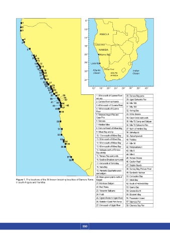
Figure 1 should please show the following 58 breeding colonies in Angola and Namibia.


                                                                   6°
                       1
                      2
                      3                                           10°
                                                                             ANGOLA
                                                                  14°
                        4
                      5
                                                                  18°    Cunene River
                          6                                                 NAMIBIA
                             7  8                                 22°        Walvis Bay
                              9  10
                                 11
                               12  13                             26°  LÜderitz
                                14  15
                                 16                                             Orange River
                                  17  18                          30°   Atlantic                    Indian
                                                                        Ocean
                                  19  20                               Atlantic     SOUTH           Ocean Indian
                                   21    22                             Ocean       AFRICA             Ocean
                                   23     24                      34°                       Port Elizabeth  power station Chatty
                                     25     27
                                      26
                                       28     29
                                        30    31                       12°   16°  20°  24°  28°  32°   36°  40°
                                         32    33
                                         34     35
                                          36     37  39                   1. 30 km north of Cunene River   28. Durissa Bay pans
                                          38        40                    estuary              29. Ugab Saltworks Pan
                                                    42
                                           41   43   44                   2. Cunene River surrounds  30. Mile 108
                                            45       46                   3. 40 km south of Cunene River  31. Mile 100
                                              48   47                     4. 100 km south of Cunene
                                                  49                      River                32. Horing Bay
                                                                          5. Between Angra Fria and   33. White Stones
                                                                          Cape Fria            34. Cape Cross surrounds
                                               50                         6. Sarusas           35. Mile 72 Camp and Saltpan
                                                                          7. Westies Mine      36. Mile 72 Saltworks Pan
                                               51                         8. 5 km northeast of Möwe Bay  37. North of Henties Bay
                                                                          9. Möwe Bay airstrip  38. Jakkalsputz
                                               52                         10. 13 km south of Möwe Bay  39. Zeila shipwreck
                                                 53                       11. 30 km south of Möwe Bay  40. Pebbles
                                                    54                    12. 50 km south of Möwe Bay
                                                      55                                       41. Mile 30
                                                  56                      13. 60 km south of Möwe Bay  42. Wlotzkasbaken
                                                                          14. Saltpans north of Terrace   43. Mile 8
                                                                          Bay airstrip         44. Mile 4
                                                      57                  15. Terrace Bay surrounds  45. Horses Graves
                                                       58                 16. Swallow Breakers surrounds  46. Caution Reef
                                                                          17. 6 km north of Torra Bay
                                                                          18. Torra Bay        47. Dolphin Beach
                                                                          19. Henrietta Spachette wreck   48. Donkey Bay, Pelican Point
                                                                          and saltpan          49. Sandwich Harbour
                                                                          20. Black gravel plains north of   50. Conception Bay
                  Figure 1. The locations of the 58 known breeding localities of Damara Terns  Koigab  51. Meob Bay
                  in south Angola and Namibia                             21. Montrose Saltpan  52. South of Hottentot Bay
                                                                          22. Red Plains       53. Guano Bay
                                                                          23. Toscanini Saltpans  54. Grosse Bucht
                                                                          24. Huab             55. Elizabeth Bay
                                                                          25. Ogden Rocks to Ugab River  56. Possession Island
                                                                          26. Skeleton Coast Park fence  57. Marmora Pan
                                                                          27. 6 km south of Ugab River  58. Chameis Bay Pan


                                                                 550