
Page 48 - 4. Pre-Course Reading-Training on Forestry Audit 2019
P. 48
Auditing Forests: Guidance for Supreme Audit Institutions
Ground check: 5. RESEARCH QUESTION: Is there
plantation in forest zone?
• To get physical evidence on GIS result, we could use GPS.
• Enter the coordinate of deforestation area into GPS.
Minimum data required:
• Use GPS to navigate us to the determined area.
• Spatial data of forest zone.
• After arriving at the area, prepare the report.
• Spatial data of land coverage.
• Spatial data of plantation area.
4. RESEARCH QUESTION: Is there land
overlapping and inappropriate land utilization?
Data analysis:
Minimum data required: • Intersect spatial data of coverage area at the beginning of
the year with data taken from the end of the year, to obtain
• Spatial data of forest zone.
new spatial data regarding the condition of area coverage
• Spatial data of LFC. between the two parts of the year.
• Spatial data of farm. • From this spatial data, do a selection based on certain attri-
48 butes. Select data which has the attribute of primary forest
• Spatial data of mine.
in the beginning of the year and plantation in the end of
the year.
Data analysis: • Then, intersect this spatial data with spatial data of forest
area. This will show which areas of primary forest contains
• Intersect gradually the above data to obtain new spatial
data that indicates overlapping land. plantations.
• To identify plantation industry responsible for the defores-
• For example, intersecting spatial data of farm with spatial tation, overlay spatial data of plantation with the above
data from LFC results in new spatial data indicating farm areas analysis results.
that are also LFC.
• Select area where there is overlapping land use.
Ground check:
• To get physical evidence on GIS result, we could use GPS.
The result can be seen in the following figure:
• Enter the coordinate of plantation area inside the protected
forest into GPS.
Figure 4
Overlapping of land utilization • Use GPS to navigate us to the determined area.
• After arriving at the area, prepare the report.
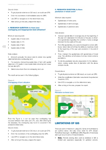
Figure 5
Plantation on forest zone
From the Figure 5, it can be seen that overlapping has
occurred between farm area and LFC, and, after referring to
the database, the overlapping was found to occurred in the LIMITATIONS OF GIS
production forest area.
Ground check:
There are some limitations in using GIS. Some of the limitations
• To get physical evidence on GIS result, we could use GPS. are outlined below. And also show what the BPK (Badan
Pemeriksa Keuangan - Audit Board of the Republic of Indonesia)
• Enter the coordinate of the overlapping area into GPS.
did to get around some of these limitations.
• Use GPS to navigate us to the determined area.
• Data. Remote sensing data used as database in GIS is
• After arriving at the area, prepare the report. limited and expensive (especially for updated version).