
Page 25 - Paparan KI Sadai_Neat
P. 25
Sadai Integrated Industrial and Port, South Bangka - Indonesia
RATION Smart Sea-Port | Logistics center | Industrial Estate
BANGKA
ABADI
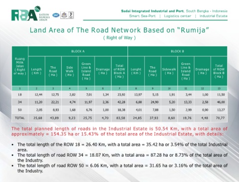
Land Area of The Road Network Based on “Rumija”
( Right of Way )
BLOCK A BLOCK B
Ruang
Milik Green Green
Jalan The Side Line & Total The Line & Total
( Right Length Road Walk Island Drainage of ROW Lenght Road Sidewalk Island Drainage of ROW
of way ) ( Km ) ( Ha ) ( Ha ) Road ( Ha ) Block A ( Km ) ( Ha ) ( Ha ) Road ( Ha ) Block B
( Ha ) ( Ha ) ( Ha ) ( Ha )
1 2 3 4 5 6 7 8 9 10 11 12 13
18 12,44 12,75 2,82 7,01 1,34 23,92 13,97 5,15 1,91 3,44 1,00 11,50
34 11,20 22,21 4,74 11,97 2,36 42,28 6,88 24,90 5,20 13,33 2,58 46,00
50 2,05 8,93 1,68 6,76 1,00 18,38 4,01 7,88 1,50 2,99 0,90 13,27
TOTAL 25,68 43,89 9,23 25,75 4,70 83,58 24,85 37,93 8,60 19,76 4,48 70,77
The total planned length of roads in the Industrial Estate is 50.54 Km, with a total area of
approximately = 154.35 ha or 15.43% of the total area of the Industrial Estate, with details:
• The total length of the ROW 18 = 26.40 Km, with a total area = 35.42 ha or 3.54% of the total Industrial
area.
• The total length of road ROW 34 = 18.07 Km, with a total area = 87.28 ha or 8.73% of the total area of
the Industry.
• The total length of road ROW 50 = 6.06 Km, with a total area = 31.65 ha or 3.16% of the total area of
the Industry.