
Page 752 - Kitab3DsMax
P. 752
Part VI: Advanced Modeling
adds a bottom to the object; and the Layered Solid displays each contour as a flat, terraced area. The Stitch
Border option causes polygons to be created to close open splines by creating a single edge that closes the
spline. The Retriangulate option optimizes how the polygons are divided to better represent the contours.
The Display group includes options to display the Terrain mesh, the Contour lines, or Both. You can also
specify how you want to update the terrain.
The Simplification rollout lets you alter the resolution of the terrain by selecting how many vertical and
horizontal points and lines to use. Options include using all points (no simplification), half of the points, a
quarter of the points, twice the points, or four times the points.
Coloring elevations
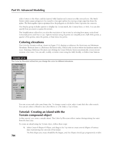
The Color by Elevation rollout, shown in Figure 27.8, displays as reference the Maximum and Minimum
Elevations. Between these is a Reference Elevation value, which is the location where the landmass meets the
water. Entering a Reference Elevation and clicking the Create Defaults button automatically creates several
separate color zones. You can add, modify, or delete zones using the Add, Modify, or Delete Zone buttons.
FIGURE 27.8
The Color by Elevation rollout lets you change the color for different elevations.
You can access each color zone from a list. To change a zone’s color, select it and click the color swatch.
You can set colors to Blend to the Color Above or to be Solid to Top of Zone.
Tutorial: Creating an island with the
Terrain compound object
In this tutorial, you create a simple island. The Color by Elevation rollout makes distinguishing the water
from the land easy.
To create an island using the Terrain object, follow these steps:
1. Select Create ➪ Shapes ➪ Ellipse, and drag in the Top view to create several ellipses of various
sizes representing the contours of the island.
The first ellipse you create should be the largest, and the ellipses should get progressively smaller.
704