Page 19 - How to Go Boating Flip 1
P. 19
avigation
When it comes time to travel somewhere in your boat, Port and Starboard
you will be faced with a plethora of new rules, required
skills and necessary equipment. There are no roads It is critically important that, right from the start, you remove left and
that take you to your destination, no white line to stay right from your thought process and replace it with port and starboard.
left of and no distance-to-go signs to guide you. To There is good reason to do so; left and right are what we usually
compound the problem, there are no gas stations on relate to our personal space whereas the port side of a boat is always
your journey out to sea. Navigation is a subject that has the port side of a boat. So, too, a port (or starboard) marker. They
filled literally thousands of books over the years. It’s a don’t change if you change your position.
great topic to explore further as your boating experience
grows. Because the subject of navigation is so broad, Port is the left-hand side of a boat, looking forward. A port-
the difficulty is not what to include here but rather what to hand marker is on the left (the port side of the boat) as you travel
leave out. Please consider this chapter as just a starting clockwise around the country or as you enter a port. Port is red, port
point. the drink is red, a port hand light is red, a boat has a red navigation
light on its port side. Notice how everything ties in beautifully and
I have broken the chapter into three parts: the first covers the lights seamlessly! Get this set in your memory and you are well on the way
and beacons that provide the ‘signposts’ on the water; the second to understanding navigation. You will also note that the left hand, or
covers the boat, principally the lighting that allows you to understand port side, of the spreads in this chapter are red and the right-hand, or
the direction being taken by other vessels on the water; and the third starboard sides, are green.
section introduces charts and the basics of navigation.
As a brief aside, those of you with an enquiring mind may have
PLEASE NOTE: Throughout this chapter there are spotted a small apparent discrepancy in the description above of
full or part charts shown. Please be aware that all the clockwise, port-hand beacon on the left entering harbour. What
charts are sourced from LINZ (Land Information happens in Cook Strait, for example? Or in a harbour with two
New Zealand) data and are not for navigation. entrances? This is an example of why it is important to have, and to
refer to, the correct nautical chart for the area you are navigating.
In the circumstances described it will show you the point where the
direction of buoyage changes.
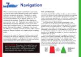
Port Buoy Starboard
Can direction Cone
Red heading in to Green
harbour
109
When it comes time to travel somewhere in your boat, Port and Starboard
you will be faced with a plethora of new rules, required
skills and necessary equipment. There are no roads It is critically important that, right from the start, you remove left and
that take you to your destination, no white line to stay right from your thought process and replace it with port and starboard.
left of and no distance-to-go signs to guide you. To There is good reason to do so; left and right are what we usually
compound the problem, there are no gas stations on relate to our personal space whereas the port side of a boat is always
your journey out to sea. Navigation is a subject that has the port side of a boat. So, too, a port (or starboard) marker. They
filled literally thousands of books over the years. It’s a don’t change if you change your position.
great topic to explore further as your boating experience
grows. Because the subject of navigation is so broad, Port is the left-hand side of a boat, looking forward. A port-
the difficulty is not what to include here but rather what to hand marker is on the left (the port side of the boat) as you travel
leave out. Please consider this chapter as just a starting clockwise around the country or as you enter a port. Port is red, port
point. the drink is red, a port hand light is red, a boat has a red navigation
light on its port side. Notice how everything ties in beautifully and
I have broken the chapter into three parts: the first covers the lights seamlessly! Get this set in your memory and you are well on the way
and beacons that provide the ‘signposts’ on the water; the second to understanding navigation. You will also note that the left hand, or
covers the boat, principally the lighting that allows you to understand port side, of the spreads in this chapter are red and the right-hand, or
the direction being taken by other vessels on the water; and the third starboard sides, are green.
section introduces charts and the basics of navigation.
As a brief aside, those of you with an enquiring mind may have
PLEASE NOTE: Throughout this chapter there are spotted a small apparent discrepancy in the description above of
full or part charts shown. Please be aware that all the clockwise, port-hand beacon on the left entering harbour. What
charts are sourced from LINZ (Land Information happens in Cook Strait, for example? Or in a harbour with two
New Zealand) data and are not for navigation. entrances? This is an example of why it is important to have, and to
refer to, the correct nautical chart for the area you are navigating.
In the circumstances described it will show you the point where the
direction of buoyage changes.
Port Buoy Starboard
Can direction Cone
Red heading in to Green
harbour
109