
Page 519 - Environment: The Science Behind the Stories
P. 519
subway stations flooded and countless vehicles and buildings
suffered damage. A fire broke out amid flooded homes in
Queens and destroyed an entire neighborhood.
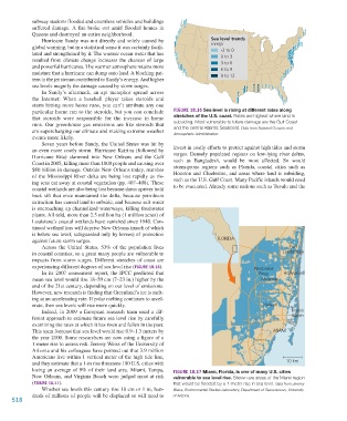
Hurricane Sandy was not directly and solely caused by Sea level trends
global warming, but in a statistical sense it was certainly facili- mm/yr
-3 to 0
tated and strengthened by it. The warmer ocean water that has 0 to 3
resulted from climate change increases the chances of large 3 to 6
and powerful hurricanes. The warmer atmosphere retains more 6 to 9
moisture that a hurricane can dump onto land. A blocking pat- 9 to 12
tern in the jet stream contributed to Sandy’s energy. And higher
sea levels magnify the damage caused by storm surges.
In Sandy’s aftermath, an apt metaphor spread across
the Internet: When a baseball player takes steroids and
starts hitting more home runs, you can’t attribute any one
particular home run to the steroids, but you can conclude Figure 18.16 Sea level is rising at different rates along
that steroids were responsible for the increase in home stretches of the U.S. coast. Rates are highest where land is
runs. Our greenhouse gas emissions are like steroids that subsiding. Most vulnerable to future damage are the Gulf Coast
and the central Atlantic Seaboard. Data from National Oceanic and
are supercharging our climate and making extreme weather Atmospheric Administration.
events more likely.
Seven years before Sandy, the United States was hit by
an even more costly storm. Hurricane Katrina (followed by invest in costly efforts to protect against high tides and storm
surges. Densely populated regions on low-lying river deltas,
Hurricane Rita) slammed into New Orleans and the Gulf such as Bangladesh, would be most affected. So would
Coast in 2005, killing more than 1800 people and causing over storm-prone regions such as Florida, coastal cities such as
$80 billion in damage. Outside New Orleans today, marshes Houston and Charleston, and areas where land is subsiding,
of the Mississippi River delta are being lost rapidly as ris- such as the U.S. Gulf Coast. Many Pacific islands would need
ing seas eat away at coastal vegetation (pp. 407–408). These to be evacuated. Already some nations such as Tuvalu and the
coastal wetlands are also being lost because dams upriver hold
back silt that once maintained the delta, because petroleum
extraction has caused land to subside, and because salt water
is encroaching up channelized waterways, killing freshwater
plants. All told, more than 2.5 million ha (1 million acres) of
Louisiana’s coastal wetlands have vanished since 1940. Con-
tinued wetland loss will deprive New Orleans (much of which
is below sea level, safeguarded only by levees) of protection
against future storm surges. FLORIDA
Across the United States, 53% of the population lives Fort
in coastal counties, so a great many people are vulnerable to Lauderdale
impacts from storm surges. Different stretches of coast are
experiencing different degrees of sea level rise (Figure 18.16). Pembroke
In its 2007 assessment report, the IPCC predicted that Pines Hollywood
mean sea level would rise 18–59 cm (7–23 in.) higher by the Miramar
end of the 21st century, depending on our level of emissions.
However, new research is finding that Greenland’s ice is melt-
ing at an accelerating rate. If polar melting continues to accel-
erate, then sea levels will rise more quickly. Hialeah
Indeed, in 2009 a European research team used a dif- Miami
ferent approach to estimate future sea level rise by carefully Beach
examining the rates at which it has risen and fallen in the past.
This team forecast that sea level would rise 0.9–1.3 meters by MIAMI
the year 2100. Some researchers are now using a figure of a
1-meter rise to assess risk. Jeremy Weiss of the University of
Arizona and his colleagues have pointed out that 3.9 million
Americans live within 1 vertical meter of the high tide line,
and they estimate that a 1-m rise threatens 180 U.S. cities with 10 km
losing an average of 9% of their land area. Miami, Tampa, Figure 18.17 Miami, Florida, is one of many U.S. cities
New Orleans, and Virginia Beach were judged most at risk vulnerable to sea level rise. Shown are areas of the Miami region
(Figure 18.17). that would be flooded by a 1-meter rise in sea level. Data from Jeremy
Whether sea levels this century rise 18 cm or 1 m, hun- Weiss, Environmental Studies Laboratory, Department of Geosciences, University
dreds of millions of people will be displaced or will need to of Arizona.
518
M18_WITH7428_05_SE_C18.indd 518 12/12/14 4:05 PM