
Page 301 - Thai Heritage from Space_ebook
P. 301
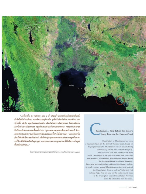
15 ํ 20’ N
                                                                                                                                       102 ํ 59’ E


                                                                      อ่าวไทย


                                                                                                                              จันทบุรี
                                                                                                                              จันทบุรี


     12 ํ 06’ N
     98 ํ 02’ E      “...ครั้นรุ่งขึ้น ณ วันอังคำร แรม ๖ ค�่ำ เดือนยี่ นำยกองจึงคุมไพร่พลหมื่นหนึ่ง

               คิดจะซ่องสุมประชำรำษฎรในแขวงหัวเมืองตะวันออกทั้งปวงให้ได้มำกแล้ว จะยกกลับเข้ำไป  C

               น�ำทัพไปถึงต�ำบลทับยำ  หยุดทัพแรมอยู่คืนหนึ่ง  รุ่งขึ้นจึงเดินทัพถึงนำจอมเทียน  และ

               ทุ่งไก่เตี้ย สัตหีบ หยุดทัพแรมแห่งละคืน แล้วเดินทัพมำทำงริมชำยทะเล ถึงต�ำบลหินโขง
               และน�้ำเก่ำแขวงเมืองระยอง หยุดพักแรมแห่งละคืนตำมระยะทำงมำ พระยำก�ำแพงเพชร
               จึงปรึกษำกับนำยทหำรและรี้พลทั้งปวงว่ำ กรุงเทพมหำนครคงจะเสียแก่พม่ำโดยแท้ ตัวเรำ
                                                                                                 hanthaburi … King Taksin the Great’s


               กู้กรุงให้คงคืนเป็นรำชธำนีอย่ำงเก่ำ แล้วจักท�ำนุบ�ำรุงสมณพรำหมณำประชำรำษฎร ซึ่งอนำถำ  Army Base on the Eastern Coast
               หำที่พักบมิได้ให้ร่มเย็นเป็นสุขำนุสุข และจะยอยกพระบวรพุทธศำสนำให้โชตินำกำรไพบูลย์       Chanthaburi or Chanthabun has been
               ขึ้นเหมือนแต่ก่อน...”                                                  a legendary town on the Gulf of Thailand coast. Based on
                                                                                        its geographical site, Chanthaburi was an estuary lining
                                                                                                 continuously till the west of Laem Sing Bay.
                               (พระราชพงศาวดารฉบับพระราชหัตถเลขา, กรมศิลปากร พ.ศ. ๒๕๔๘)           The town was rich with healthy earth from
                                                                                        basalt - the origin of the precious stones that symbolize
                                                                                        this province. It is believed that settlement began during
                                                                                                   the Dvaravati Period until now. Evidently,
                                                                                      there were traces of earthen dykes at Ban Nawan and the
                                                                                     city walls - moats around Chanthabun on the west bank of
                                                                                              the Chanthaburi River as well as Yothanimit Fort
                                                                                          in Bang Kaja. This fort was on the earth mound close
                                                                                              to the lower plain west of Chanthaburi Province
                                                                                                         some 13 kilometers from the coast.


                                                                                                                               l  287  287