Page 299 - Thai Heritage from Space_ebook
P. 299

13 ํ 44’ N
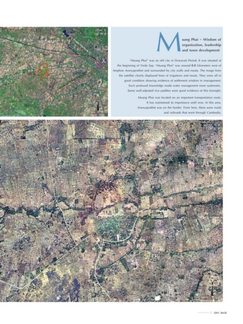
                                                         102 ํ 30’ E                          M               uang Phai - Wisdom of

                                                                                                              organization, leadership
                                                                                                              and town development
                                             ทางหลวงหมายเลข 33
        ห้วยเดื่อ         กุดม่วง        ห้วยพรหมโหด                           “Muang Phai” was an old city in Dvaravati Period. It was situated at
                                   ห้วยไผ่
                                                                       the beginning of Tonle Sap. “Muang Phai” was around 6.8 kilometers west of


                  เมืองไผ่                                          Amphoe Aranyaprathet and surrounded by city walls and moats. The image from
                                                                        the satellite clearly displayed lines of irrigations and moats. They were all in
                                ห้วยพันท้าว  ทางหลวงจังหวัดหมายเลข 3067    good condition showing evidence of settlement wisdom in management.
                                                                              Such profound knowledge made water management more systematic.
                                                                             Some well-adjusted rice paddies were good evidence of this foresight.
                                                                                   Muang Phai was located on an important transportation route.
                                                           N
                                                                                         It has maintained its importance until now. In this area,
                                                                                   Aranyaprathet was on the border. From here, there were roads
 13 ํ 37’ N
 102 ํ 21’ E                                             150 m.                                    and railroads that went through Cambodia.

 เมืองไผ่                                                                                                                     13 ํ 42’ N
 อ�ำเภออรัญประเทศ จังหวัดสระแก้ว                                                                                              102 ํ 27’ E


                                                                                      ห้วยไผ่


                                                                                                                               N


 13 ํ 40’ N
 102 ํ 24’ E                                                                                                                  250 m.


                                                                                                                               l  285  285
   294   295   296   297   298   299   300   301   302   303   304