
Page 325 - Thai Heritage from Space_ebook
P. 325
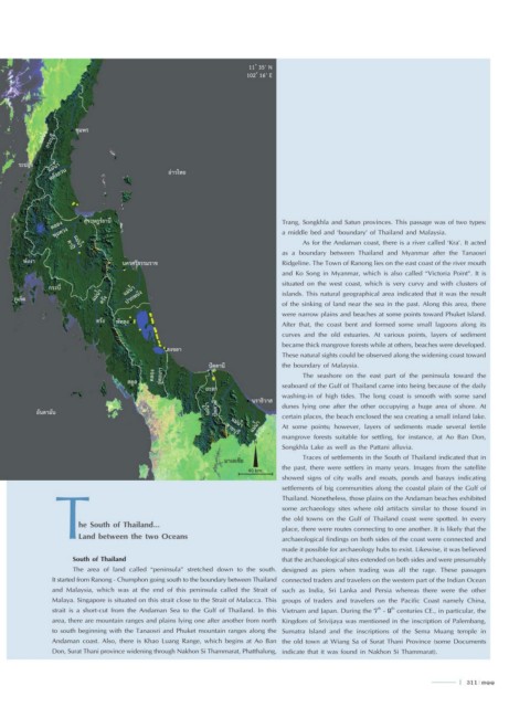
11 ํ 35’ N
                                                                     102 ํ 16’ E


                      ชุมพร
            แม่นํ้า  กระบุรี


      ระนอง   แม่นํ้า
               หลังสวน                         อ่าวไทย


               คลอง     สุราษฎร์ธานี                                          Trang, Songkhla and Satun provinces. This passage was of two types:
                พุมดวง                                                        a middle bed and ‘boundary’ of Thailand and Malaysia.
                                                                                    As for the Andaman coast, there is a river called ‘Kra’. It acted
                     แม่นํ้า
                                                                              as a boundary between Thailand and Myanmar after the Tanaosri
                   ตาปี
       พังงา                      นครศรีธรรมราช                               Ridgeline. The Town of Ranong lies on the east coast of the river mouth
                                                                              and Ko Song in Myanmar, which is also called “Victoria Point”. It is
                                                                              situated on the west coast, which is very curvy and with clusters of
              กระบี่               แม่นํ้า
     ภูเก็ต                แม่นํ้า  ตรัง  ปากพนัง                             islands. This natural geographical area indicated that it was the result
                                                                              of the sinking of land near the sea in the past. Along this area, there
                                                                              were narrow plains and beaches at some points toward Phuket Island.
                           ตรัง  พัทลุง                                       After that, the coast bent and formed some small lagoons along its
                                                                              curves and the old estuaries. At various points, layers of sediment
                                                                              became thick mangrove forests while at others, beaches were developed.
                                               สงขลา
                                                                              These natural sights could be observed along the widening coast toward
                                                          ปัตตานี             the boundary of Malaysia.
                                           คลอง  อู่ตะเภา                           The seashore on the east part of the peninsula toward the
                                    สตูล
                                                         ยะลา                 seaboard of the Gulf of Thailand came into being because of the daily
                                                                              washing-in of high tides. The long coast is smooth with some sand
                                                                      นราธิวาส
           อันดามัน                                       แม่นํ้า  ปัตตานี    dunes lying one after the other occupying a huge area of shore. At
                                                                              certain places, the beach enclosed the sea creating a small inland lake.
                                                                      แม่นํ้า  โก-ลก  At some points; however, layers of sediments made several fertile
                                                                แม่นํ้า
                                                               สายบุรี
                                                                       N      mangrove forests suitable for settling, for instance, at Ao Ban Don,
                                                                              Songkhla Lake as well as the Pattani alluvia.
                                                                                    Traces of settlements in the South of Thailand indicated that in
                                                              มาเลเซีย
                T                                                             settlements of big communities along the coastal plain of the Gulf of
 5 ํ 13’ N                                                                    the past, there were settlers in many years. Images from the satellite
 97 ํ 36’ E                                                          40 km.   showed signs of city walls and moats, ponds and barays indicating

                                                                              Thailand. Nonetheless, those plains on the Andaman beaches exhibited
                                                                              some archaeology sites where old artifacts similar to those found in
                                                                              the old towns on the Gulf of Thailand coast were spotted. In every
                      he South of Thailand...
                                                                              place, there were routes connecting to one another. It is likely that the
                      Land between the two Oceans
                                                                              archaeological findings on both sides of the coast were connected and
                                                                              made it possible for archaeology hubs to exist. Likewise, it was believed
                     South of Thailand                                        that the archaeological sites extended on both sides and were presumably
                     The area of land called “peninsula” stretched down to the south.    designed as piers when trading was all the rage. These passages
               It started from Ranong - Chumphon going south to the boundary between Thailand   connected traders and travelers on the western part of the Indian Ocean
               and Malaysia, which was at the end of this peninsula called the Strait of   such as India, Sri Lanka and Persia whereas there were the other
               Malaya. Singapore is situated on this strait close to the Strait of Malacca. This   groups of traders and travelers on the Pacific Coast namely China,
               strait is a short-cut from the Andaman Sea to the Gulf of Thailand. In this   Vietnam and Japan. During the 7  - 9  centuries CE., in particular, the
                                                                                                         th
                                                                                                            th
               area, there are mountain ranges and plains lying one after another from north   Kingdom of Srivijaya was mentioned in the inscription of Palembang,
               to south beginning with the Tanaosri and Phuket mountain ranges along the   Sumatra Island and the inscriptions of the Sema Muang temple in
               Andaman coast. Also, there is Khao Luang Range, which begins at Ao Ban   the old town at Wiang Sa of Surat Thani Province (some Documents
               Don, Surat Thani province widening through Nakhon Si Thammarat, Phatthalung,    indicate that it was found in Nakhon Si Thammarat).


                                                                                                                               l  311  311