Page 329 - Thai Heritage from Space_ebook
P. 329

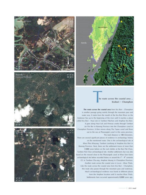
เขาสามแก้ว                                        10 ํ 31’ N
                 อ�ำเภอเมืองฯ จังหวัดชุมพร                          99 ํ 12’ E


                                                                                                   สหภาพเมียนมา


                                                                                  อันดามัน
                                                                                                                           อ.ละอุ่น


                                                                    N

                                                                                                            จ.ระนอง
                                                                   300 m.
                 10 ํ 30’ N
                 99 ํ 10’ E                                    © GISTDA_2011


                 บ้านปากจั่น                                       10 ํ 31’ N
                 อ�ำเภอกระบุรี จังหวัดระนอง                         98 ํ 50’ E

                                                                                             T


                                                                                                   he route across the coastal area …
                                                                                                                Kraburi - Chumphon


                                                                                    The route across the coastal area from Kra Buri - Chumphon
                                                                                   is another passage going mainly through the mountain pass and
                                                                    N
                                                                                  water way. It starts from the mouth of the Kra Buri River on the
                                                                              Andaman Sea up to the beginning of the river until it reaches a place
                                                                             called Kra Buri - Huai Lek in Tambon Pakchun and Amphoe Kra Buri.
                 10 ํ 30’ N                                        200 m.             It goes along Huai Lek and Hinwao creeks through Tambon
                 98 ํ 49’ E                                    © GISTDA_2014
                                                                                     Jor Por Ror in Ranong Province into the Chumphon canal in
                                                                              Chumphon Province. It then moves along Tha Tapao canal and flows
                 เขาพระขยางค์                                      10 ํ 20’ N
                 อ�ำเภอกระบุรี จังหวัดระนอง                         98 ํ 47’ E         out to the sea at Phanungtak canal in this same province.
                                                                                                        The total distance is 130 kilometers.
                                                                              There are several significant pieces of evidence in archaeology history
                                                                                        on the mentioned route. One is the archaeological site at
                                                                                    Khao Phra Khayang, Tambon Lumliang of Amphoe Kra Buri in
                                                                               Ranong Province. Next, there are the settlement traces of more than
                                                                                     2,000 years before on the rock shelter at the Ban Pak Chun,
                                                                              Tambon Pak Chun archaeological site. Another settlement clue was also
                                                                             found on the mound close to the Phanungtak canal at Khao Sam Kaew
                                                                              archaeological site before recorded history or around the 1  - 4  centuries
                                                                                                                          st
                                                                                                                             th
                                                                                 CE. in Tambon Cha-ang, Amphoe Muang in Chumphon Province.
                                                                                     Another route across the coastal area is La-un - Khao Thalu.
                                                                                 Like the route across the coastal area from Kra Buri - Chumphon,
                                                                    N              this route also passes through the mountain pass and waterway.
                                                                                      Much archaeological evidence was found at different places
                                                                                          from the Amphoe location until it reaches Khao Thalu.

                 10 ํ 18’ N                                        600 m.              Settlements here occurred approximately 8,000 years ago.
                 98 ํ 45’ E                                    © GISTDA_2014


                                                                                                                               l  315  315
   324   325   326   327   328   329   330   331   332   333   334