
Page 333 - Thai Heritage from Space_ebook
P. 333
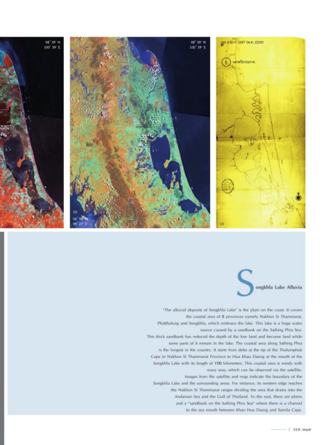
08 ํ 39’ N                                                     08 ํ 39’ N   เดอ ลามาร์ 1687 (พ.ศ. 2230)
                    100 ํ 39’ E                                                     100 ํ 39’ E


                                                                                                      นครศรีธรรมราช


 พรุควนเคร็ง                                                พรุควนเคร็ง


                                 (2)
                                 06 ํ 58’ N
                                 99 ํ 27’ E                                                      (3)


                                                                                                        S       ongkhla Lake Alluvia


                                                                        “The alluvial deposits of Songkhla Lake” is the plain on the coast. It covers
                                                                                  the coastal area of 3 provinces namely Nakhon Si Thammarat,
                                                                      Phatthalung and Songkhla, which embrace the lake. This lake is a huge water
                                                                                        source caused by a sandbank on the Sathing Phra Sea.
                                                                 This thick sandbank has reduced the depth of the low land and become land while
                                                                           some parts of it remain in the lake. The coastal area along Sathing Phra
                                                                       is the longest in the country. It starts from delta at the tip of the Thalumphuk
                                                                   Cape in Nakhon Si Thammarat Province to Hua Khao Daeng at the mouth of the
                                                                    Songkhla Lake with its length of 156 kilometers. This coastal area is windy with
                                                                                           wavy seas, which can be observed via the satellite.
                                                                                  Images from the satellite and map indicate the boundary of the
                                                                    Songkhla Lake and the surrounding areas. For instance, its western edge reaches
                                                                            the Nakhon Si Thammarat ranges dividing the area that drains into the
                                                                             Andaman Sea and the Gulf of Thailand. To the east, there are plains
                                                                              and a “sandbank on the Sathing Phra Sea” where there is a channel
                                                                                  to the sea mouth between Khao Hua Daeng and Samila Cape.


                                                                                                                               l  319  319