Page 337 - Thai Heritage from Space_ebook
P. 337

พะโคะ                                                                     07 ํ 36’ N
                                                                          100 ํ 23’ E


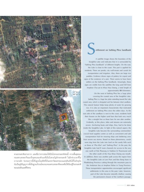
                                                                                         S        ettlement on Sathing Phra Sandbank


                                                                                                 A satellite Image shows the boundary of the
                                                                                           Songkhla Lake and indicates that it is surrounded by
                                                                                      “Sathing Phra Sandbank” of different lengths. On the east,
                                                                                          the Lake is close to the coast. This part is applied for
                                                                                      residents. There are ponds, city wall-moats and canals for
                                                                                          transportation and irrigation. Also, there are large rice
                                                                            N           paddies. Evidence shows signs of pottery for export and
                                                                                      signs of the existence of a pier. There seems to have been
                                                                                        settlers on the Sathing Phra Sandbank. Amazingly, these
                                                                           200 m.
 07 ํ 35’ N                                                                           signs are visible from the satellite: the long sand hill from
 100 ํ 23’ E                                                          © GISTDA_2013      Amphoe Cha-uat to Khao Hua Daeng, a total length of
                                                                                                              approximately 89 kilometers.
 สทิงพระ                                                                   07 ํ 36’ N
                                                                          100 ํ 23’ E           On the west of Sathing Phra lies a large plain
                                                                                               covering the coastal area of the Songkhla Lake.
                                                                                          Sathing Phra is a huge low plain extending toward the Lake
                                                                                     coastal area, which is elongated and lies between short sandbars.
                                                                                      This natural feature helps keep plenty of water for growing
                                                                                        rice. It is also an important characteristic that motivated
                                                                                        settlement on Sathing Phra since the olden days. As the
                                                                                     east side of the sandbars is next to the coast, residents built
                                                                                       their houses on the higher sand bars that look very much
                                                                                          like a straight line as these bars lie one after another.
                                                                                        Evidently, at this place, tides and streams are extremely
                                                                                       severe. Anchoring boats and ships, thus, had to be done
                                                                                     inside the Songkhla Lake. In light of this natural aspect, the
                                                                                          Songkhla Lake became the surrounding communities’
                                                                                     crucial food supplies centre as well as convenient and safe
                                                                                       transportation hub for mooring ships and sheltering crew
                                                                                     from severe sea storms. Based on these phenomena, canals
                                                                                      were dug from the Lake into land on the sandy hills such
                                                                                      as those at “Pha Kho” and “Sathing Phra”. In the past, the
 07 ํ 36’ N
 100 ํ 24’ E                                                          © GISTDA_2014   Songkhla Lake had 2 main channels for access to the sea:
                                                                                       one north of Pak Phanung in Nakhon Si Thammarat and
               ตามธรรมชาติอย่างถาวร และเชื่อว่าหากปล่อยให้เป็นไปตามธรรมชาติเช่นนี้ ความสิ้นสุดของ   the other south of the Hua Khao Daeng sea mouth.
               ทะเลสาบสงขลาก็จะมาถึงจุดจบของตัวเองที่เป็นไปตามวัฏจักรธรรมชาติ  ในอีกช่วงเวลาที่ไม่   In addition, there was another path across the region from
                                                                                         the Songkhla Lake at Lum Pum and Ban Bang Kaeo in
               ยาวนานนัก ร่องรอยการตั้งถิ่นฐานในอดีตที่เป็นมรดกวัฒนธรรมบนแผ่นดินเห็นได้ในปัจจุบัน    Phatthalung Province cutting through the mountain pass to
               นับเป็นภูมิปัญญาการตั้งถิ่นฐานบริเวณโดยรอบทะเลสาบสงขลาที่หลงเหลือให้เรียนรู้ถึงธรรมชาติ  the Andaman Sea at Amphoe Palian in Trang Province.
               ของแผ่นดินและชีวิตคน                                                    These transportation opportunities encouraged significant

                                                                                            settlements in this area in the past. Later, however,
                                                                                            part of the Lake became naturally shallow causing
                                                                                               the permanent closure of the northern passage.


                                                                                                                               l  323  323
   332   333   334   335   336   337   338   339   340   341   342