Page 339 - Thai Heritage from Space_ebook
P. 339

08 ํ 36’ N                                                         07 ํ 45’ N
                                                               100 ํ 31’ E                                                         100 ํ 10’ E
                                                                                                                     ตรัง
                                                                                                                  คลองปากประ

                             นครศรีธรรมราช


                                                                                           คลองมะกอกใต้


                                                                                                     คลองตรุด    คลองเรือ


                                                                                        เมืองชัยบุรี


                                พัทลุง                                                                           เมืองพญาขัน
             ตรัง


                                                                                 คลองสาน                               คลองสาน


                                                                                                       คลองควนแร่                ลําป�า
         ปะเหลียน                                                                อ.เมืองพัทลุง
                                                                  สงขลา
                                                                                                         เมืองพระรถ
                                                                  N                                                                  N


       06 ํ 58’ N                                                          07 ํ 35’ N
       99 ํ 27’ E                                               20 km.     100 ํ 01’ E                                              2 km.


                                                                                             “    C


                                                                                                      haiburi”… the mountainous town
                                                                                                              and sea port to the Lake


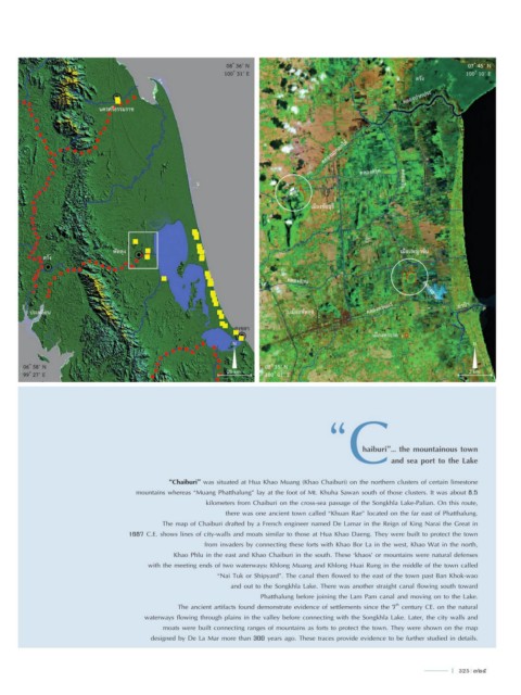
                                                “Chaiburi” was situated at Hua Khao Muang (Khao Chaiburi) on the northern clusters of certain limestone
                                       mountains whereas “Muang Phatthalung” lay at the foot of Mt. Khuha Sawan south of those clusters. It was about 8.5
                                                          kilometers from Chaiburi on the cross-sea passage of the Songkhla Lake-Palian. On this route,
                                                                there was one ancient town called “Khuan Rae” located on the far east of Phatthalung.
                                              The map of Chaiburi drafted by a French engineer named De Lamar in the Reign of King Narai the Great in
                                     1687 C.E. shows lines of city-walls and moats similar to those at Hua Khao Daeng. They were built to protect the town
                                                          from invaders by connecting these forts with Khao Bor La in the west, Khao Wat in the north,
                                                 Khao Phlu in the east and Khao Chaiburi in the south. These ‘khaos’ or mountains were natural defenses
                                          with the meeting ends of two waterways: Khlong Muang and Khlong Huai Rung in the middle of the town called
                                                              “Nai Tuk or Shipyard”. The canal then flowed to the east of the town past Ban Khok-wao
                                                                 and out to the Songkhla Lake. There was another straight canal flowing south toward
                                                                          Phatthalung before joining the Lam Pam canal and moving on to the Lake.
                                                                                                               th
                                                   The ancient artifacts found demonstrate evidence of settlements since the 7  century CE. on the natural
                                         waterways flowing through plains in the valley before connecting with the Songkhla Lake. Later, the city walls and
                                              moats were built connecting ranges of mountains as forts to protect the town. They were shown on the map
                                           designed by De La Mar more than 300 years ago. These traces provide evidence to be further studied in details.


                                                                                                                               l  325  325
   334   335   336   337   338   339   340   341   342   343   344