
Page 343 - Thai Heritage from Space_ebook
P. 343
07 ํ 16’ N
100 ํ 36’ E
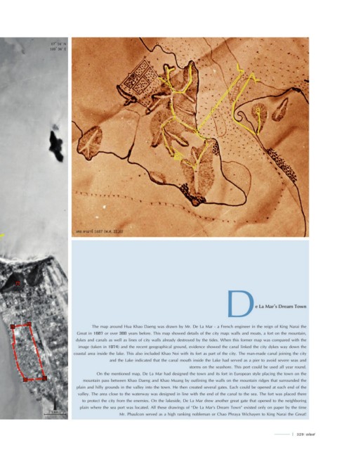
เดอ ลามาร์ 1687 (พ.ศ. 2230)
D e La Mar’s Dream Town
The map around Hua Khao Daeng was drawn by Mr. De La Mar - a French engineer in the reign of King Narai the
Great in 1687 or over 300 years before. This map showed details of the city map: walls and moats, a fort on the mountain,
dykes and canals as well as lines of city walls already destroyed by the tides. When this former map was compared with the
image (taken in 1974) and the recent geographical ground, evidence showed the canal linked the city dykes way down the
coastal area inside the lake. This also included Khao Noi with its fort as part of the city. The man-made canal joining the city
and the Lake indicated that the canal mouth inside the Lake had served as a pier to avoid severe seas and
storms on the seashore. This port could be used all year round.
On the mentioned map, De La Mar had designed the town and its fort in European style placing the town on the
mountain pass between Khao Daeng and Khao Muang by outlining the walls on the mountain ridges that surrounded the
plain and hilly grounds in the valley into the town. He then created several gates. Each could be opened at each end of the
N valley. The area close to the waterway was designed in line with the end of the canal to the sea. The fort was placed there
to protect the city from the enemies. On the lakeside, De La Mar drew another great gate that opened to the neighboring
plain where the sea port was located. All these drawings of “De La Mar’s Dream Town” existed only on paper by the time
1 km. Mr. Phaulcon served as a high ranking nobleman or Chao Phraya Wichayen to King Narai the Great!
l 329 329