
Page 341 - Thai Heritage from Space_ebook
P. 341
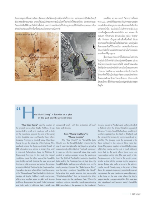
ข้ามคาบสมุทรเปลี่ยนความนิยม เลื่อนลงทางทิศใต้ออกสู่ทะเลอันดามันที่ปากบวรา และไกลออกไปถึงเมืองไทรบุรี   แผนที่โดย มร.เดอ ลามาร์ วิศวกรชาวฝรั่งเศส
               เมื่ออังกฤษเข้าครอบครอง และจนถึงปัจจุบันศักยภาพความเป็นเมืองท่าในส่วนด้านใต้ของอ่าวไทย ยังคงประกายแสง พ.ศ. ๒๒๓๐ แสดงให้เห็นสภาพสองฝั่งปากทะเลสาบสงขลา
               เรืองรองให้เห็นได้ด้วยท่าเรือที่สร้างขึ้นใหม่ บนซากก�าแพงเมืองเก่าที่ยังปรากฏร่องรอยให้เห็นได้ด้วยภาพจากดาวเทียม  ภายหลังที่กองทัพอยุธยาเอาชนะเมืองสงขลาที่แข็งเมือง
               เปรียบเทียบกับแผนที่ที่ท�าขึ้นครั้งสมัยสมเด็จพระนารายณ์มหาราช                    มาก่อนหน้านั้น  จับเจ้าเมืองได้แล้วท�าลายเมืองและ
                                                                                                กวาดต้อนผู้คนจนเหลือแต่แผ่นดินใน พ.ศ. ๒๒๒๓ ฝั่ง
                 แผนที่เดอ ลามาร์ พ.ศ. 2230                                            07 ํ 15’ N
                                                                                      100 ํ 36’ E  ตะวันตก ที่หัวเขาแดง มีก�าแพงเมือง-คูเมือง “สิงขระ”
                                                                                                หรือ “สิงหนคร” เป็นรูปยาวคล้ายสี่เหลี่ยมผืนผ้า มีแนว

                                                                                                ซากก�าแพงที่ชายฝั่งทะเลโยงถึงป้อมหัวเขา และมีคูเมือง
                                                                                                ล้อมรอบเขาน้อยไว้ในเขตเมือง  และต่อเชื่อมกับคลอง
                                                                                                ไปออกท่าเรือที่อ่าวเขาเมืองติดทะเลสาบด้านใน ซึ่งปลอดภัย

                                                                                    แหลมสมิหลา  จากคลื่นลมได้ทุกฤดูกาล
                                                                                                     ฝั่งตะวันออก (บ่อยาง) ที่ตั้งเมืองสงขลาในปัจจุบัน
                                                                                                ในสมัยนั้นไม่มีการตั้งบ้านเรือนอยู่อาศัยที่เป็นชุมชน บริเวณ
                                                                                                ติดน�้าห่างจากเขาตังกวนมาทางทิศใต้ แสดงลักษณะคล้าย

                                                                                                เป็นที่ลุ่มป่าชายเลน ปัจจุบันมีก�าแพงเมืองเป็นขอบเขตแสดง
                                                                               หัวเขาแดง
                                                                                          บ่อยาง  ไว้ในภาพ ในสมัยพระบาทสมเด็จพระนั่งเกล้าเจ้าอยู่หัว
                                                                                         N
                        ปากทะเลสาบสงขลา                                                         โปรดเกล้าฯ ให้ย้ายผู้คนที่อยู่อาศัยหนาแน่นบนฝั่งตะวันตก
                                                             07 ํ 11’ N                         ที่แหลมสนข้ามมาฝั่งตะวันออกที่บ่อยาง  มีขอบเขตวัง
                                                             100 ํ 32’ E   ปากทะเลสาบสงขลา  2 km.
                                                                                                เป็นศูนย์กลาง ซึ่งได้พัฒนาต่อเนื่องเจริญมาเป็นเมืองสงขลา
                                                                                                ปัจจุบัน


                “     H


                                  ua Khao Daeng” - location of a pier
                                      in the past and the present times


                      “Hua Khao Daeng” was the location of  concerned solely with the protection of harsh  Sea was moved to Pak Bara and further extended
                the ancient town called Singha Nakhon. It was  tides and streams.               to Saiburi when the United Kingdom occupied
                surrounded by walls and moats as well as forts                                  this area. To date, Songkhla has been an efficient
                on the mountains opposite the end of the canal   From “Muang Singkhara” to      southern seaboard on the Gulf of Thailand and
                to the Songkhla Lake and Samila Cape where         “Muang Songkhla”             the ruins of the former city were mapped out by
                Songkhla Province is situated today. Hua Khao   The “Sea Mouth” or “Songkhla Lake  satellite. The images could be compared with
                Daeng lies on the sharp tip of the Sathing Phra  Mouth” was the Songkhla Lake’s channel to the  those outlined in the reign of King Narai the
                sandbank where the long coast (total length of  sea. It was internationally significant as a trading  Great. The present location of Songkhla Province,
                156 kilometers) was almost a straight line until  sea port south of the Gulf of Thailand. Moreover,  which lies mostly on the east, is much different
                it reached Talumphuk Cape in Nakhon Si  it was an effective powerful place that could  from that in the past where there were no
                Thammarat Province. In the past, the natural  control a trading passage across the peninsula  communities on this side. The area south of Mt.
                conditions made the plain around the Songkhla  from the Gulf of Thailand through the Songkhla  Tungkuan used to be close to the sea in a way
                Lake fertile and rich helping the area grow and  Lake and to the Andaman Sea. At that time, the  similar to that of the lowland in the mangrove
                develop as a big town and sea port on the passage  Songkhla Lake had two crucial exits: one on the  forests. Today, city walls as seen in the picture
                across the Gulf of Thailand to the Andaman Sea.  north passing through the “Pakphanung River”  can be traced. Nonetheless, in the reign of King
                Nowadays, the area where Khao Hua Daeng was,  and the other - south of “Songkhla Lake Mouth”  Rama III, residents in densely-populated areas at
                is the “Tinnasulanont” Sea Port built on the former  following the route across the peninsula  Laemson on the west coast were ordered to move
                location of Singha Nakhon’s walls and moats,  “Phatthalung-Palian” that cut through the Khao  to Bo Yang on the east coast where the King’s
                which were washed away by tides and streams  Luang ranges to the Andaman Sea. When the  palace was the counterpoint of life. This area was
                and have disappeared for good. Today’s sea port  northern exit was naturally closed approximately  later developed and became today’s Songkhla
                was built under a different logic, which was  300 years before, the passage to the Andaman  Province.


                                                                                                                               l  327  327